By Michael Holloway - member, Ward 30 Bikes
This article is intended to initiate a discussion towards creating more people-centred public spaces along the flanks of the Carlaw Avenue Corridor between Queen and Gerrard via a very-local network of complete streets treatments and multi-use paths that together, become 'Invitations' to active transportation choices; routes that will - for walkers and cyclists - connect neighbourhood destinations and public amenities already in place along this dangerous corridor which is congested with motor vehicle traffic most of the day.
Below is Ward 30 Bikes representative, Michael Holloway's submission via the Online Survey posted for the 3rd round of the Carlaw + Dundas Public Realm Initiatives public consultation (as per the June 21, 2016 Open House at Morse Street School Gym - http://www.carlawdundas.ca/about-project). Michael Holloway attended all the events through this two-and-a-half year process.
Only the sections of the survey where Michael wrote in feedback are represented in this article. This edited presentation does not include all the Options, or the Images that supported unanswered Options that appeared on: the paper survey; the display boards at the Morse Street School event; or in the Online Survey (which is unfortunately now closed - http://fluidsurveys.com/s/CarlawDundas/)
_________________
Page 2 (16%)
Preliminary Jimmie Simpson Gateway Concept Design Options
Option 1 - Colgate Avenue Gateway
[no answer]
Option 2 - Colgate Avenue Gateway
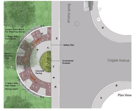
Option 2 - What do you like? Why?
Like. Arc is welcoming.
Option 2 - What would you change? Why?
Ornamental Grasses - replace with naturally occurring vegetation in a bioswale - which pools temporarily, runoff from storm events in a wet/dry bowl feature planted with naturally occurring vegetation. Funnel the entrance feature and near-by sidewalk's run-off into this bioswale.
Perhaps copy at this entrance the existing stainless steel checker plate, 19″ high letter inlay in the sidewalks at the corner of Queen/Broadview? Perhaps with the words "Jimmy Simpson Park"
---
The Entrance feature is for active transportation modes - so it is an entrance way for pedestrians, cyclists, parents with strollers, skateboarders, elderly with mobility devices, the blind using their canes, and so on.
So:
1) Create a pedestrian and cyclist friendly Colgate Ave from Carlaw to Booth (I suggest wider sidewalks between Carlaw and Natalie Place; bike lanes along the entire stretch where possible, sharrows where not possible - safety treatments at transition pinch points (like where the roadway changes widths at Natalie Place); dedicated cycle crossing lanes beside the cross hatches of a new crosswalk across Colgate/Booth;
2) Create entrance features that assist active transportation modes - narrow the crossing area at Booth with bump-outs, add dual pedestrian crosswalk / mounted cyclists' crossing, add blind (and sighted) crosswalk signals;
3) Create pathways in the Park that allow egress for all active transportation modes, to and from the Park's amenities.
(Best practice might be to wait some time after the entrance way is completed and investigate where people travel in the Park via the new entrance - and then add appropriately placed Multi-use Trails at a later date);
4) And add elements along those routes which support the people using them at the amenities which they are using - like 11 Ring & Post bike lock-ups for the soccer field (ie. enough lock-ups for two full teams) placed along the west side of Booth north of Colgate connected to the entrance feature via a Multi-use Path; similarly at the skating rink, basketball pad, tennis pad, hockey pad - and especially - at the main entrance to the recreation centre.
(Existing are too few and badly placed - currently hidden under a tree with no lighting; rather, needs to be 'front and centre', well lit, and near the doors ... in order to keep 'eyes' on the lock-up area. Also, the existing bike lock-up amenity is of bad design and is broken and rusting).
Option 2 - How does the proposed concept meet your needs?
[no answer]
Option 3 - Booth Avenue and Queen Street Gateway
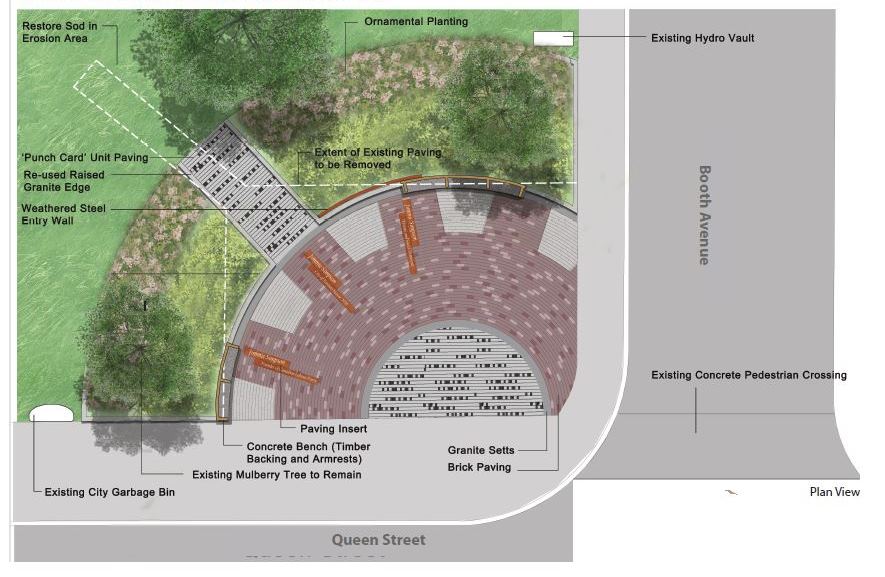
Option 3 - What do you like? Why?
Arc is welcoming.
Option 3 - What would you change? Why?
Existing feature has bad sight-lines at night - feels scary there - seating is hidden away in the shadows; the entire construct blocks a view into the Park behind it. Open it up, but at the same time provide a friendly space to hang out and active transportation amenities for those who travel to the Park via this entrance-way.
Option 3 - How does the proposed concept meet your needs?
[no answer]
Page 3 (50%)
Preliminary Boston Avenue Boulevard Improvements
What do you like? Why?
Like the walking path - but it ends at a parking lot. People using the space have created their own walking path - installing a regulation path won't help the underlying issues -> no sight-lines, dark, path doesn't connect Dundas to the residential buildings.
In my opinion, connecting the walking path to the residential buildings is the only way to create a sustainable public space here; otherwise this is a waste of money.
To make this connection, perpendicular private parking on the west side of Boston from the empty lineal space down to the south face of 245(R) Carlaw should be ended somehow - perhaps an accommodation with the landowners (if this is private land) to improve the back of their building (tattered old fence, rutted gravel driveway) at the same time as a sidewalk and a boulevard is constructed.
This could be done by swinging the parking to parallel along this section, which at the same time would make room for a connection between the winding path to the existing sidewalks to the south. Plus there are lots of empty parking spaces in the lot at the southeast corner of Dundas/Boston.
Bike Lanes
Also, Boston is a good candidate for a contraflow bicycle lane. A northbound contraflow on Boston would help residents of the nearby developments connect to Dundas - and via Heward - to Eastern.
Queen / Carlaw intersection centres a vibrant local community, Boston as a north-south bike route allows 8/80 cycling to the Dundas and Eastern Avenue Bikes lanes (which provide an 8/80 route to the lake front).
Carlaw is not a presently a cycling street. It is congested during peak hours (7 hours a day) with tense, hopped-up LSB commute drivers.
Oddly, the street it is considered a 'destination' by planning staff - yet there is no safe way to bicycle to any of the places along Carlaw between Queen and Dundas; thus connecting cyclists to area destinations - and nearby commuter routes - via Boston and via Logan/Colgate as I've stressed above) would be an ideal alternative to Carlaw.
Page 4 (66%)
Signature Marker Design Competition Shortlist Submissions
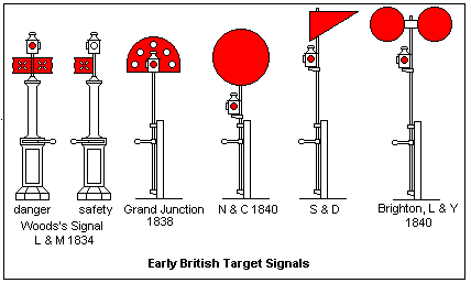
Submission #3: Pierre Poussin - "Brick Obelisk"
Best of the lot. But penile, and there's already too much of that at this corner.
How about something penile that has to do with Trains (as it is on the historical railway easement).
Perhaps a sculpture that evokes the classic railway signal post - made out of old rail tracks! (Classic railway signal posts:
 |
| Via Dr Elizabeth R. Tuttle Professor of Engineering, University of Denver - https://mysite.du.edu/~etuttle/rail/sigs1.gif |
Or - a scale miniature of an old railroad station house - made of scale sized bricks?
.. An old railroad station house?
 |
| Via Esprit Co - http://edc.h-cdn.co/assets/cm/15/04/980x653/54c1a7c9c72a7_-_devera-edc-04-14-3-xln-xln.jpg |
End
mh
