Friday, February 28, 2014

Proposed Felstead Avenue Filtered Access for Bicycles - Site Visit

Ward 30 Councillor Paula Fletcher, City Staff and Ward 30 Bikes conduct a site visit to see if it's possible to create an cut-through on this Traffic Island - Felstead Avenue, one block West of the Greenwood Bike Lanes, four blocks South of Danforth.

Below we're measuring just how wide we can make the cut, by measuring existing posts nearby that - to us cyclists - 'feel' comfortable riding between.

Felstead Ave Cut-Through Site Visit - 2014-02-28 9:00AM - with R. Joshi (camera), J. White, D. Egan, Councillor Fletcher, P. Young, M. Holloway.

The first factor was making sure the cut was wide enough for the width of a Bike Trailer - hopefully this cut-through can be Much wider than that.

I explained - wider means we care, *that wide* about cycling as a legitimate form of transportation.

"How much do we care?" chimed in Paul Young, "1.7m" - was his own answer.  :)

Huntley St & Earl Place
Wider Please.

With the Traffic Island fairly buried in snow - it was hard for Staff to tell, but it looks like it's a poured curb with paving blocks just laid in on top of the black-top. If this is so, the plan would be to cut the curbs and create two islands; with a nice wide path right down the middle. A similar (but not wide enough) cut-through was accompluished at Huntley St and Earl Place last year (see image - right).

We noted several things that needed to be fixed up on the structure - so our cut-through may also make the amenity better at the same time - bring it back up to it's original state at any rate.

A neighbour we talked to told us that all kind of kids and cyclists use this street - she talked about how everyone just hopped the curb and rode on the sidewalk.

Cut-through site visit - 9am, Friday Feburary 28, 2014 - looking North across a snowed-in Felstead Ave Traffic Island

A cyclist came though during our time there, doing the curb-hop thing - I mentioned as he passed me that we we were trying to get a path-through created. He immediately said "Great!" - as he hopped down off the sidewalk and onto the street again, heading towards the Greenwood Bike Lanes.

More of us ride the winter than most people think.

Looking East at the snowed-in Felstead Ave Traffic Island 2014-02-28

 ______________________


Top image via Councillor Paula Fletcher Tweet: https://twitter.com/PaulaFletcher30/status/439436962479357952


mh

Wednesday, February 26, 2014

Felstead Ave Connections & Opportunities for better Quality Connections


I took a bicycle ride and made a map that shows how the Felstead Ave route 'cut-through' can connect several existing Cycle Infrastructure via On-Street Routes and Informal Connections - some of which also provide opportunities for better Quality connections.

@Ward30Bikes - Felstead Ave Connections Map

View @Ward30Bikes - Felstead Ave Connections in a larger map

The box describes connections to existing East-West & North-South Cycling Infrastructure. The line along the top of the map is the Felstead East-West Route from the O'Connor Bridge over to Broadview Avenue.

The route allows cyclists who do not wish to ride on Danforth Avenue, a route to get to the Downtown via this East West route to Broadview, from which they can access the Bloor Viaduct Bike Lanes to get to up-town destinations along Bloor Street East and West.

The East-West Felstead Route also makes connections to North-South Bike Lanes on Greenwood Avenue and Jones Avenue. These separated lanes then connect to major East west commute routes that feed into either mid-town via Dundas Bike Lanes; or the Finacial Core and the Lake Front via the Lower Don Recreation Trail and Queens Quay Bike Lanes.


The Bike Ride

The "Informal Connections" were all bare to pavement - and located where they were supposed to be.

The 'Trail' part of the route, East out of the Parkette over to Phin and then across another Park (TTC land?) to Oakvale - are sidewalks. At the edge of Phin Avenue Parkette the sidewalk is also the front door-stoops of a row of 5, two story semi-detached homes there.

Google Street View - Phin Ave West to Phin Avenue Parkette Informal Connection - is actually a neighbourhood sidewalk. Perhaps a Multi-Use Trail around the South edge of the Parking Lot?


We could think about how this route might serve the community if it were expanded into a wide, well marked Multi-Use Trail. This route undoubtedly already acts as a cycle and walking route to the school just to the North - Eastern Commerce Collegiate.

Turning around and looking East from the POV in the image above, is East on Phin Ave as it curves around - to another Park area - looks like part of the TTC land there. Again a narrow sidewalk could be a Multi-Use Trail.

Google Street View - Phin Ave East towards Oakvale Ave. The Informal Connection is a narrow sidewalk; perhaps a Multi-Use Trail here?


At Oakvale and Greenwood I turned Southbound for three blocks down to Felstead Avenue. With the speed of Greenwood there, the left turn onto Felstead from southbound Greenwood is scary even for an experienced cyclist.

Greenwood is very wide on that stretch I rode; we should think about Greenwood as a candidate for some measures to calm automobile traffic on it. It's too wide - feels like a highway, rather than an Avenue

The Felstead/Greenwood intersection has a Crosswalk on the south side of it. We can think about how to make that safer.

Although I didn't ride the route northbound - the same is likely true at the Oakvale/Greenwood intersection.


On Felstead Avenue


The Felstead Street Closure is currently a place used for snow storage Looks like the City Operators - and the Catholic School Operator are piling snow on it.

Felstead is a favourite East-West Route of mine - I discovered it several years ago - it goes all the way from Main Street (down the Woodbine Steps & up the Woodbine Steps) and the rest - all the way to Broadview is on your seat.

Southbound to Woodfield - via Monarch Park


At Monarch Park there seems to be a Trail that people use along the Western edge of the park. It was footfalls in the snow, frozen like fossils. This image from Google Street View - taken in the summer - shows that under the winter snow is a walking path, the width of a narrow sidewalk.

Google Street View - Falstead Ave looking South along the Western edge of Monarch Park - sidewalk could be a Multi-Use Trail, straight down to the Tunnel


I wanted to explore the edge path but my hip told me not to risk it - falling on jagged ice is not good for cycling. So I took the North-South maintenance and policing access road through the middle of the Park (it runs south of the end of Gillard Ave). It was clear and bare to pavement all the way to the Tunnel.

The Park itself is great - full of Public Amenities (a blow-up dome houses a football pitch! (told me a dad plying soccer with his son on this -12°C day) - and old tree growth; like the canopy at Kew Gardens in the Beaches.

The GO Rail Tunnel

Monarch Park access road, looking South at the approach to the Tunnel under the GO Tracks
Looking North at the approach to the Tunnel into Monarch Park under the GO Tracks


The Tunnel is a 'deep' place in the South-West corner of the Park - but the painting and the openness of the tunnel feel pretty good. The areas either side of the tunnel could do with benches for people to sit on. On the Woodfield side, a neighbour has actually added some up on a hill-top overlooking the dip. Needs play facilities. It's surrounded by homes and would make a great place for a local community play destination.

Over my shoulder and up the incline behind me fro this image POV, is Woodfield Road - which goes all the way down to the Lower Don Rec Trail - passing on the way, the Dundas Bike Lanes and Eastern Avenue - which has no bike lane at Woodfiled - it starts at Leslie Street - about a 2 minute ride West. (Hint, Hint)

From the right lane on Woodfield Rd at Eastern Ave - looking West on Eastern Ave - towards the TTC Russell Yard


mh

Saturday, February 15, 2014

"Nothing short of everything" - i hate my life; I hate this thing

I've been through planning.

What I saw is democracy filtered out reality.

Here's the thing:

The Tragically Hip: "Now For Plan A"
Sounds like Eno. Bigger.
If we plan to plan out of hell - will the hell we live in be the opal we see out through?

Nothing short of everything.


Pablo Neruda (1904–1973) http://memory.ucsf.edu/blog/june-poems-of-the-month-683/


OK

I fogot there's good too. And a lot of it.

Lets just see what tomorrow brings.

Wheat Kings


Bobcaygeon


The Tragically Hip - 'It's A Good Life If You Don't Weaken'


mh

Friday, February 14, 2014

TTC Leslie Barns Street Reconstruction - Cyclist & Pedestrian Detour Issues: North/South Walking Routes


I went for several walk-abouts this week, of the TTC Leslie Barns Construction site on Leslie between Queen St East and Commissioners - Video Camera in hand. This article is mainly about the deplorable condition of the Walking Detour infrastructure around the site

This is one of three articles I am publishing this week on the condition of cycling and pedestrian detour infrastructure around the Leslie Barns new Streetcar Barns project - and the Leslie Street reconstruction to accommodate Street Car rail beds.

Specifically I'm looking at the condition of the Lower Don Recreation Trail and the Martin Goodman Trail through the area, and connections to that important and essential infrastructure.

 ______________________


I started my walk at the corner of Queen St. and Leslie St. - where the TTC Leslie Barns street reconstruction has narrowed the through lanes at the intersection down to one lane in each direction on both Streets. Cyclists who have confidence issues driving with car traffic may want to choose another route around this as you'll have to change lanes across street car tacks in likely slippery conditions, and ride with car traffic in the centre lanes.


North-West Corner of Queen St and Leslie - looking south-east at the intersection.
Leslie street continues north through the zone with one lane - one-way northbound, as usual. Southbound Leslie is one lane in each direction.

Looking westbound along Queen St E. just East of Leslie St. from the North side of the street. The curb lanes in either direction on Queen have been closed.

Looking North at the intersection from the construction median.
Standing in the centre construction median on Leslie St - looking North at Queen St. - watching an SUV turning right down Leslie from Queen; while northbound cars line up at the light.
 
It's a construction zone - be careful - but as in all construction zones, traffic is moving pretty slow due to the narrow lanes.

For cyclists: It's one lane through the intersection in all directions. Don't let cars push you to the dangerous snow & ice conditions near the curb - you could lose your wheels and fall into the lane and get hit. I advise cyclists Take The Lane through all construction zones - the speed of cars through them isn't (shouldn't be) any faster than the speed of a casual cyclist - 10-15 km/h (because there are people on foot working there!)

@TTCLeslieBarns Public Liaison Office and Ward 30 Bikes worked together to broadcast a @Ward30Bikes, Cyclists' East-West Detour Route Map around the Queen St lane restriction:


Sidewalks: North-South, Eastern Ave to Lake Shore Boulevard


Turning South now from Queen, the situation remains as it has been over Christmas and January. The image compilation below sums it up:

The West-side sidewalk is still detoured West on Moseley for about 25m.

The East-side sidewalk along the edge of the Loblaws lot is still a 'sidewalk to no-where'. It ends about 40m North of the Plaza Entrance Intersection. Through the TTC Leslie Barns Public Liaison Committee I've notified Loblaws, FreshCo and Transportation Services that the situation for peestrians and cyclist in and around these parking lots is very dangerous and does not allow accessibility --- and suggested fixes.

For the record, here are the issues - again:


There is no signed or painted route for Pedestrians at any point South of here - folks are using the driveway, the parking lot, the Entrance-way lanes to Leslie St and the Drive-Tru's at the fast food joints as sidewalks.

Tracks in the snow at the end of the sidewalk-to-nowhere, indicate that pedestrians are using Leslie Street and the driveway in the Loblaws lot to go North-South.

Sidewalk on Leslie South of Eastern ends about 40m North of the Plaza Entrance Intersection; a sidewalk to nowhere. Folks are using both Leslie Street and the Loblaws lot driveway (One-way South) to walk North-South

Evidence of the crowd sourced, driveway-sidewalk: tracks over a bank of snow at the edge of a parking area, leading to sidewalks at the South side of Loblaws:

Left: Loblaws One-way Southbound driveway-come-sidewalk. Right: Egress to Loblaws South-side entrance doors from the 'Driveway-Sidewalk'.


Just South of there - at the Loblaws, Leslie St Entrance - Pedestrians are crossing Leslie along the South side of the intersection.

Here's a view looking West across the Loblaws, Leslie St. Entrance to the FreshCo Entrance. The truck is exiting the construction road closure area across a 'crowd sourced' crossing which cyclists and pedestrians use to access the neighbourhood from the Lower Don Rec Trail and other points West and South: 

I'm standing on the defacto pedestrian-way. There are no markings or signs showing pedestrians where to go - or same to let drivers know that they should expect people walking. As they arrive in the Loblaws Parking lot there are no markings or useful signage. Below is a useless warning sign on the construction fencing on the North side of the Loblaws Leslie St Entrance - facing the wrong way..

Pomerleau Construction's Pedestrian Warning Sign (behind the pole and the cone on the fence) at right-angles to the defacto pedestrian crossing point.


Further South I noted a foot-path in the snow leading towards the North-East corner of Leslie St. & Lake Shore Blvd. - indicating pedestrians are walking through the Loblaws parking lot - across the entrance-way lanes - and then through the Burger King Drive-Thru lanes in order to complete their North-South trips. I found the same thing at The Tim Hortons / Wendy's on the North-West corner.
Foot-path off the Burger King Drive-Tru - looking South to Lake Shore Blvd. and Leslie St.


On the West side, I found the sidewalk between the west fence of the construction zone and the Tim Hortons / Wendy's Drive-Thru, for 3 days the condition of the sidewalk was a one-foot-directly-in-front-of-the-other narrow path. Baby strollers, walking assist devices, wheel chairs and two-way foot traffic are all defeated by this sub-par snow plowing. 

@TTCLeslieBarns has informed me this sidewalk is City of  Toronto responsibility.

I've Tweeted it in to @311Toronto https://twitter.com/311Toronto


(For the safety and efficiency of Pomerleau's highly skilled work-force if I were them, I would take responsibility for the sidewalks around a site in winter.)


LDRT at Leslie/Lake Shore could be wider/safer


The crosswalk across Leslie Street on the North side of Lake Sore Boulevard could be much wider - by about 1.5m wider by my measurement. If a concrete barrier - like is being employed on the right in the picture was installed it would better separate car and active modes - and making the area safer for active transportation users.

The Crosswalk across Leslie St on the North side of Lake Shore Boulevard could be twice as wide. About 2m on the left in the picture is being used for snow storage.


 ______________________


More on Walking and Cycling detour conditions around this major construction coming soon. Next time the LDRT at the Temporary Entrances to the two Big Box Stores "Plazas"; and South of Lake Shore - the MGT.


mh

TTC Leslie Barns Street Reconstruction - Cyclist & Pedestrian Detour Issues: A Dangerous Configuration at Lake Shore Blvd. Crosswalk


A Dangerous Configuration - Lake Shore Boulevard at Leslie St. - East-side Crosswalk


The @TTCLeslieBarns related Leslie Street reconstruction detour configuration has moved the right turn lane on northbound Leslie Street 26m to the West of the crosswalk. As drivers make their eastbound turn and approach the crosswalk there are no signs or pavement markings indicating they are approaching a crosswalk.

For Cyclists and Pedestrians proceeding South if feels like you're in no-man's land.

For crosswalk users Northbound, the crosswalk begins in a 'doorway' in the construction fencing - no sight-lines to the West - so all they see is the blinking Walk sgnal beckoning them out into the East bound lanes. Drivers accelerating on the boulevard over the 26m from the corner often reach speeds of 25km/h by the time they reach the unmarked crossing. These are deadly collision speeds.

I shot videos of it that show fairly well what the problem is. I do a running commentary on Parts 2 and 3 - both of which were shot one day after Part 1.

@Ward30Bikes - Pt. 1 Hazardous Pedestrian/Cyclist Crossing, Lake Shore & Leslie - N/E Corner POV 2014-02-12 5:30pm


@Ward30Bikes - Pt. 2 Hazardous Pedestrian/Cyclist Crossing, Lake Shore & Leslie - N/E Corner POV 2014-02-13 12:30pm


@Ward30Bikes - Pt. 3 Hazardous Pedestrian/Cyclist Crossing, Lake Shore & Leslie - N/W Corner POV 2014-02-13 12:40 pm


(Tweeted the sidewalk issue to @311Toronto on 2014-02-14)


Coming soon - more on Walking and Cycling detour conditions around this major reconstruction. The FreshCo Temporary Entrance video and lots of issues on the Martin Goodman Trail on the South side of Lake Shore Blvd..


mh

Sunday, February 9, 2014

@CycleToronto - @Ward30Bikes, @Ward32Spokes making progress improving East Side Cycling Routes


Last Summer Ward 30 Bikes held a series of Mapping Meetings - intended to identify problems with the cycling infrastructure already in place; and opportunities to connect informal cycling routes that users have identified.

Two of those opportunities are currently in the process of becoming realized.

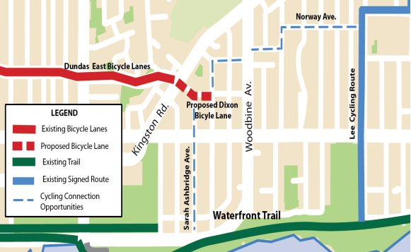
Dixon Avenue Contra-flow Bike Lane


Greg Burrell, from Ward32Spokes added this item to Ward30's Problems/Opportunities Map.

This one lays outside the boundaries of Ward 30 - but is on an important East-West cycle route that Ward 30 cyclists use all the time. The Dixon Ave Contra-flow is off the eastern end of the Dundas Bike Lanes at Kingston Road.

The Dundas Bike Lanes run through Ward 30 and part way into Ward 32 (about half-way between Coxwell and Woodbine). Dundas Street ends at Kingston Road but Dixon Road continues east from there over to Woodbine - but for car traffic-flow reasons - it's signed One-way westbound at Kingston Road for about 90 metres to Lockwood Rd - where it reverses and goes one-way eastbound over to Woodbine.

The One-way at Kingston forces eastbound cyclists coming off the Dundas Street Bike Lanes to tempt fate and take the one-way wrong-way on Dixon for 90 metres. For West bound cyclists - they aren't even aware Dixon leads to the Dundas Lanes - because they never take it off Woodbine - it's one-way eastbound at that end.


Councillor Mary-Margaret McMahon, and Ward32Spokes are working now with Transportation to get a Contra-flow on Dixon  A public meeting is scheduled for Tuesday, February 18 at the Beaches Recreation Centre - 6 Williamson Rd, Toronto, ON M4E 1K5.

See: Beach Metro, "New bike lane may be coming to the Beach"   http://www.beachmetro.com/2014/02/04/bike-lane-coming-beach/

Below is Ward32Spokes map of the Contra-flow proposal, and all the connections that it enables (I understand that the current process only deals with Dixon Avenue from Kingston Rd. to Brookmount Rd. - the dashed red line on the map):

 @Ward30Spokes Map - Dixon Avenue Contra-flow and connecting routes (received - 2014-02-07)


Felstead Ave Filtered Access for Cyclists


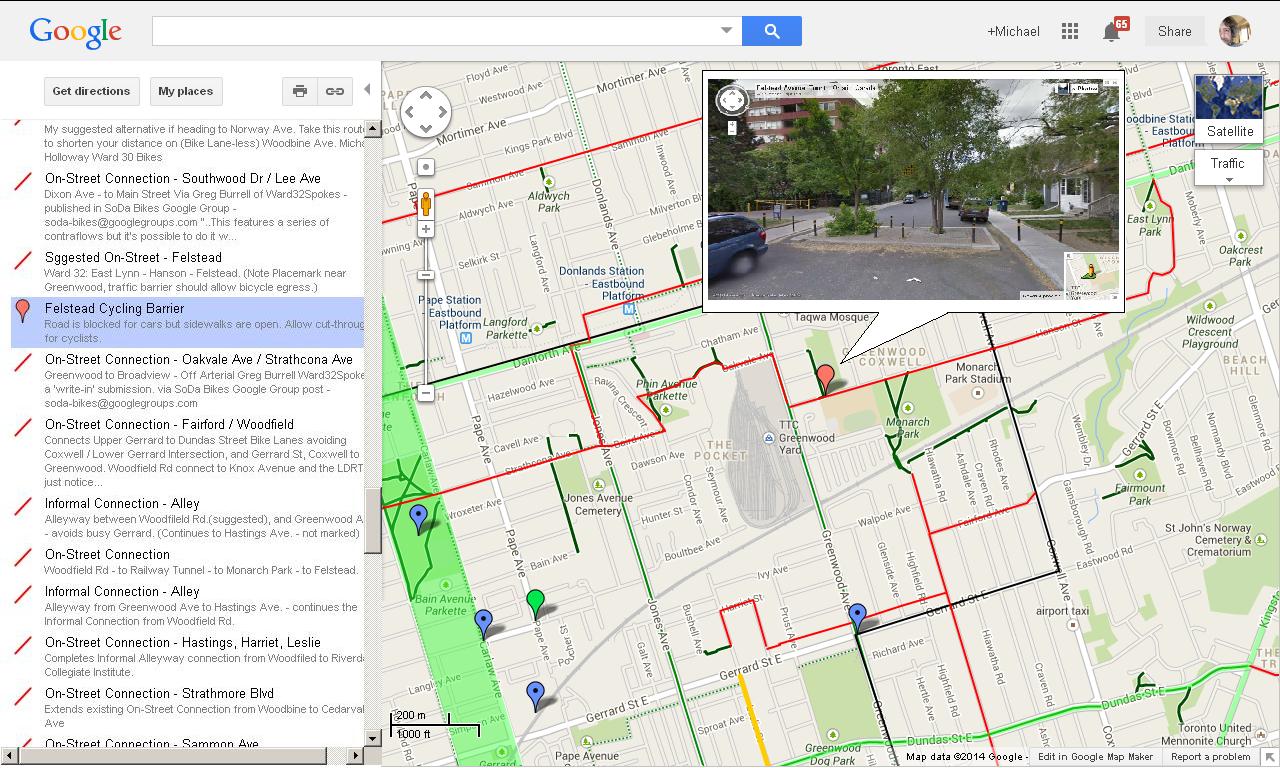
Also on Ward 30's Problems/Opportunities map, in the north-east of the Ward - is Michael Polanyi's opportunity on Felstead Avenue (East off Greenwood, four blocks South of Danforth)

Felstead Ave. has a traffic island on it that prevents car access past St Patrick Catholic Secondary School. Michael asked that a Cyclist's 'Cut-though' be made in the island to allow cyclists through.

 Google Map image "CycleTO Ward 30 Bikes: Problems/Opportunities" (http://goo.gl/maps/C7h9v)


If you look at the Street View image (that I've cleverly pasted into the pop-up bubble), you can see the traffic calming island installed there.

The island was installed to prevent cars from using Felstead Ave. as a high speed through-route between Coxwell and Greenwood. That's because there is a school just out of the image to the left, a big Park to the right, and Monarch Park a block East.

Councillor Paula Fletcher has just mailed Transportation Division about our opportunity and requested a walk of the site with staff.

Councillor Paula Fletcher's Tweet from Feb 6, 2014


Ward 30 Bikes and Councillor Paula Fletcher are working with Transportation Division to see if we can begin a process to get a Cyclists' cut-through here.

The Cut-through will look very much like this one on Huntley Street - in Ward 28 (South off Bloor St E. four blocks south at Earl Place (image right - cut-through on Huntley leading onto Earl Place).

The 'Filtered Access' on Felstead Ave. just doesn't make it 'nice' for kids cycling to and from school or the Parks there - is also connects important East-West and North-South Cyclist routes --- so their parents who commute by bicycle into the core everyday can stay off Danforth, Gerrard, Kingston Road and Queen Street East - which are insanely dangerous during peak hours (all the time).

The red lines on the Ward 30 Map are 'suggested on-street routes' that cyclists have added to the map. The dark green lines (see image above) are City of Toronto Transportation's 'on-street routes'. The dashed green are 'suggested informal routes' - both of which appear on the City of Toronto yearly Cycling Map. Notice how the red lines connect existing routes - and how Felstead is key to two of them.

This cut-through enables a route from O'Connor Dr. near the O'Connor Bridge in the north-east, down to the Danforth Ave at East-Lynne Park (via Woodmount Ave) that connects - via Felstead - to Broadview Ave in just below Danforth . As well, the Felstead route helps connect south - via the new Tunnel treatment under the Tracks at Monarch Park - which allows a connection to the Dundas Bike Lanes, the Lower Don Recreation Trail, and the Martin Goodman Trail - all of which are important East-West Bicycle Commute Routes.

CycleTO Ward 30 Bikes: Problems/Opportunities

View CycleTO Ward 30 Bikes: Problems/Opportunities in a larger map

We identified many ways improvements can be made:
  • Identify Dangerous Street Design - so that Transportation Staff are aware of cyclists' perspective;
  • Contra-flow Bikes Lanes - wrong-way lanes for cyclists on one-way streets
  • Bike Boxes - to make traversing intersections safer; 
  • Bike Lanes - streets where we thought there needed to be separated infrastructure for cyclists; 
  • On-Street routes and Informal Connections - improvements along routes that cyclists were using parallel to high-speed Avenues;
  • Bike and Pedestrian painted-on through-ways in huge Big-Box Store Plaza Parking Lots; 
  • "Fly-over" Bridges - Pedestrian/Cyclist only light-weigh structure where no On-street route is possible;
  • Tunnels - places where railway and highway corridors block connections between neighbourhoods; 
  • Road Reconstruction - streets where the condition of the roadway makes cycling hazardous; 
  • Trail Intersections - crossings along Recreation Trails where the design is hazardous to cycle traffic;
  • Multi-Use Paths in Parks - ways to create cycling and pedestrian infrastructure through City Parks; 
  • Maintenance Issues - places where Bike Lane markings were fading; 
  • Speed Bumps - some Tommy Thompson Park traffic calming measures were identified as hazardous to cyclists and a barrier to accessibility;

And we've plotted the fixes and issues on the map where we think solutions are needed. In Google Maps (link under map above) scroll down the left sidebar to see them all listed with a description. To see more info (and images) click on one, and a pop-up window will open on the map).

Please add your Problem Opportunity to the Map - and don't worry about wreaking it - we have back-up files to fix.

If you don't map, leave your idea in comments here - or at the two links listed in the sidebar of the map. We'll add your observations to the map for you!


mh

Thursday, February 6, 2014

Future of the Gardiner Expressway East - Public Forum #3 - money, jobs and fanciful artists' renderings enable thousands of car trips

Yesterday I posted this notice in Facebook at the City of Toronto Cycling site:


Future of the Gardiner Expressway East - Public Forum #3
Toronto Reference Library (The Bram & Bluma Appel Salon)
789 Yonge Street Toronto, ON M4W 2G8
Thursday, 6 February 2014
6:30 PM to 9:00 PM

The Gardiner ends at about the middle of McCleary Park (south side of the Lake Shore Boulevard) 1 block west of Logan Avenue.

If East Side Cyclists want a north South route in the area then it would be a whole lot more possible if the Remove the Gardiner option is chosen (just like was done from Logan to Woodbine).

I have been active online in this study process - tomorrow night I'll attend this event representing Cycle Toronto's advocacy group, Ward 30 Bikes.
(https://www.facebook.com/groups/140997182582942/permalink/819865268029460/?stream_ref=3)


To my great sorrow - this is what I posted under it the next night:

What I heard tonight was business as usual. In all four options - no Complete Streets visioning. After pointing out that one of the Terms of Reference was opening the City to the Lake Front - there wasn't one mention of how any of the options would do that.

To me the key to developing a livable city; is a city that is walkable, a city that is connected - one neighbourhood to the other. A city where cycling is a major component of the transportation mix.

The presentation I watched in person tonight, spent 15 seconds on cycling - and showed slide after slide of lineal aspects of the expressway - in all four options.

Big Fail

The 4 Stakeholders sitting at the table right beside me seem OK with it. Wrong stakeholders I think.

Very disappointing.

On the positive side, all the aspects which seemed to drive this part of the process - money, jobs and fanciful artists' renderings - seemed to point to the Remove option - which with-in it, seems to only consider a 'replace' with a 'Grand Boulevard'. The Grand Boulevard, a situation we here in Riverdale/Leslieville know - solves nothing towards opening up the city to the water front - if your main threads are money jobs and badly conceived architecture.

The staring point in city building is people - that's why the public consultation process - not so you can hoodwink and confuse while the powerful developer interests ram through their unsustainable economic planning - but rather - to make the space livable.

Livable spaces are arrived at by asking neighbourhoods of people what they want. The result is place people want to be - and then the people will come. Make sure the built form will facilitate the things those people are likely to need when they begin to enjoy themselves there - and that bring the development, the businesses and the jobs - and then the housing all of which will begin to evolve the new built form of the new place.

Staring with how many cars you can slam through a neighbourhood (now all dead along the edges of this thing) is no way to vision our children's Water Front.

In the last consultation I envisioned large wide open spaces at many, many crossing points. Crossings that were Complete Streets - with wide streets that could hold: mass transit to move masses of people, wide side walks where people would feel comfortable walking, separated 'slow traffic' infrastructure - for bicycles and other emerging low carbon emission, sustainable modes - and car lanes.

Obviously no one preparing this monstrosity read that one.
 (https://www.facebook.com/groups/140997182582942/permalink/819865268029460/?comment_id=820901844592469&offset=0&total_comments=12)


References:

Waterfront Toronto | Gardiner East Environmental Assessment - www.waterfrontoronto.ca/explore_projects2/the_wider_waterfront/the_gardiner_expresswaygardiner east environmental assessment

Video of the evening's proceedings: http://hosting.epresence.tv/livemedia/52/page/Home.aspx

Future of the Gardiner Expressway East - Public Forum #3 - Presentation Slides: http://www.gardinereast.ca/sites/default/files//documents/GE%20-%20Presentation%20-%20PIC%2002%20-%20FINAL.pdf

Live Twitter feed of the hashtag, #gardinereast - https://twitter.com/search?q=%23gardinereast&src=hash

Online Survey (same questions as the live participants engaged; watch the presentation, review the presentation slides, and then fill this out if you like - will be included in the public feedback portion of the assessment process) - http://fluidsurveys.com/s/GardinerEastEA-PIC3-HaveYourSay/


mh

Tuesday, February 4, 2014

Queen St., Logan, Port Lands, South of Eastern, Dundas/Carlaw Corridor - a walk-about to discover North-South Cycling Opportunities

Learning through reading, walk-abouts and writing: Bouchette Street, Logan Avenue & Carlaw Avenue --- Commissioners to Dundas


I did a walk-about of the 'South of Eastern Employment Area' in a corridor which includes Carlaw Ave, Logan Ave - and south of Lake Shore, a possible connection from Broadview - Bouchette Street. My walk-about started at Queen Street and Logan, down to McCleary Park and then Bouchette Street to Commissioners. I returned to the neighbourhood via Carlaw from Lake Shore up to the Dundas Bike Lanes.

The map below shows the southerly route in green, and the return trip in red. The purple line is: 'Jeez! I wish that on the way back I had continued east on Commissioners for one block over to Carlaw and the Turning Basin!'  (click on place marks and lines for more route data and short narratives).


View Walking the Port Lands Planning Precincts in a larger map

I was looking for a way to create a North-South Cycling Corridor - as many have suggested a need for this in our Problem/Opportunities outreach to the East Side Community (see CycleTO, Ward 30 Bikes - Problems/Opportunities Map: http://goo.gl/maps/Musw4).

Here' my walk about route Friday December 13, 2013 - on an image of the Port Lands Master Plan pedestrian/cycling map. My walk-about route down is in Green - back up is in Yellow (extending up to Dundas St East).
City of Toronto Planning - Transportation and Servicing Master Plan - Page 5 of 9 - Pedestrian/Cycling Network Map (top of the map is about half way to Queen St.)
(Note how I tried to cross Lake Shore Blvd. at rush hour - bad idea - getting to the median at 5pm was easy, but then I couldn't get across the eastbound lanes no matter how long I waited it seemed. Eventually I decided I had to walk on the median east from Logan to the lights at Carlaw - but saw a walking opportunity, and crossed through grid-locked traffic, about a football field's length from the lights.)

These connectivity issues are being addressed by City of Toronto Planing in their "Transportation and Servicing Master Plan" study - a part of the "Port Lands Acceleration Initiative" - an over-all planning process for the Port Lands and the South of Eastern Avenue area which extends from the Don River over to about Coxwell and down to Unwin Avenue.

To connect the Port Lands and the Waterfront to the city, I'm also exploring north of Eastern by walking it, and reading the Dundas/Carlaw Corridor Study Documents (see link below) - and then also I intend to walk up to Riverdale Ave (just below Withrow Park) - above which the cycling / pedestrian conditions become much better. (There are issues - but those for another post.)

There's a lot to digest in these five Port Lands studies - so I'm making my way through the Transportation and Servicing Master Plan documents first - and at the same time walking the connection routes through the study areas - and - writing up my learning and understandings gleaned from the process as I go.

___________________


Below is an image I produced from City of Toronto Planning, Transportation and Servicing Master Plan, page 5 of 9 - zoomed to 800% - showing part of their proposed Pedestrian/Cycling Network that this article focuses on: Contra-flow Bike Lanes on Carlaw and Logan - intended to connect the existing neighbourhoods to the new Port Lands and to the Waterfront.

City of Toronto Planning  - Transportation and Servicing Master Plan - Page 5 of 9 Zoom -  Pedestrian/Cycling Network - Contra-flow Bike Lanes on Carlaw and Logan below Eastern

On Logan Avenue the Master Plan suggests a One-way with a Contra-flow Lane and On-street Parking.I'm not particularly fond of Contra-flows as we have designed them so far, they are not intuitive (plus one feels like car drivers don't understand it - don't expect you there. Perhaps paint on the street is a fix). So when I did my walk I was imagining either painted on Bike Lanes or a separated Cycle Track along one side.

I started my walk at Queen Street East and Logan Avenue at about 4:30pm (rush hour is just beginning to peak into grid lock). The street seems quite narrow (is it? - tape measure next time), so to add a North-South Bike Route to the street it was either make Logan Ave a One-Way and put in a Contra-flow Bike Lane - or maintain the two-way street, narrow the lanes and add a separated Cycle Track on one side, and keep On-Street parking on the other.

I'll leave out South of Lake Shore for this post - it's a whole different thing. At this time I'm more concerned with how we are going to connect to it, rather than how we may wish to develop it - except to say -  visioning 30% active transportation - aka Complete Streets.

Coming back up I took Carlaw. Carlaw is one of five "Gateway" to the Port Lands - since it already goes across Lake Shore Boulevard. Plans in 2010 and 2012 have always included this and a possible extension with a bridge south of the turning basin. So Lake Shore to Eastern I imagined Carlaw with wider sidewalks; narrower lanes and a Cycle Track along the West side - with on-street parking on the East side. Or - Bike Lanes on both sides - which means no on-street parking (lots of push-back there).

Same goes for Carlaw Ave below Eastern. It seems very uncomfotable walking there - especially on the west side sidewalk at Lake Shore. On the East side sidewalk planners have already installed a Complete Streets deep corner that feels a whole lot safer.

Continuing up Carlaw the sidewalks are really narrow and the buildings seem to almost brush your shoulder as you're walking.

I was thinking wider sidewalks two car lanes and a cycle track on the West side - perhaps On-Street parking on the East side if there's room - but I doubt it.


Above Eastern Carlaw Ave seems to open up a little - I imagine a Cycle Track along the West side of the street - two lanes for cars and On-street parking on the East side of the street.

Placing the Cycle Track on the West side of Carlaw works nicely with Morse Street Public School - kids (and their parents) should enjoy (be relieved) having the cycle track take them right to their schools' front door.

Bike Parking Amenity and Car Parking at Morse Street Jr. Public School - looking South from the middle of Carlaw - just South of Queen

Morse Street Jr. Public has a 30-car Parking Lot just South of the building. Just to the North of the car park beside the driveway for the parking lot is an aging, rusted bike rack of bad design (not useful if you want to lock your back wheel). The contraption sits tilting slightly, amidst weeds growing through the cement on the border of a collapsing textured area near the rear doors of the school.


Image - City of Toronto Transportation Services, Bicycle
Infrastructure Unit - Queen Street West Bicycle
Parking Study Slide Deck (page 15 of 20)
As part of my visioning here I see losing one-third of the car parking and installing a canopied bike parking amenity on the parking lot area closest to the school - narrowing the driveway to the lot so cars cannot use it and make that the entrance-way for bikes. The car park entrance can come from the alleyway to the South.

From here walking North you come to Queen Street and the beginning of the Dundas/Carlaw Corridor Study Area. Again it looks like the same Cycle Track on the West side. The sidewalk on the North-west corner has been widened to accomodate the Bus stop - this area feels good.

I believe Planners at the T&EY-CC Planning Workshop have imagined wider sidewalks up this side of Carlaw here. (Phase One of the Dundas/Carlaw Corridor Study is completing now - another Public Workshop is scheduled in January 2014 - Documents at Councillor Paula Fletcher's website: http://paulafletcher.ca/discover-ward-30/community-planning/#carlaw

The building under construction just above Colegate Ave on the West side has created a raised fronting that will allow sitting there. This structure looks to allow the sidewalk to widen to the comparable width to that of the Bus Stop area at the corner to the South at Queen. The Dundas/Carlaw Corridor Study also suggests Colegate gets a Complete Streets treatment - narrowing the roadway and expanding the sidewalks as an pedestrian friendly corridor West over to Jimmy Simpson Park.

The East side of Carlaw through here feels like a wall. The sidewalks need to be widened here. I suggest losing a lane and adding trees and seating amenities.

There is a break between the two long street fronts (between 239 & 345 Carlaw) that could add to the illusion that the wall of existing built form is broken up; for example a big tree pushing out into the street-view looking South would do it. Also the hydro lines running along the street on the east side add to the lineal 'wall effect' and could be buried when the street is reconstructed.

The Canyon Effect on the East Side of Carlaw looking South from in front of 245 Carlaw - arrow shows alleyway between 235 & 245 Carlaw - break sight lines by burying wires; shaped steel lattice-work between buildings with ivy; large sculpture; colour ...
___________________


That's  it for now.

I'll scout Logan and Carlaw below Lake Shore Boulevard next. My walk along the south side of Lake Shore Boulevard and down Bouchette Street and a little West on Commisioners on Friday the 13th was Really interesting! But I'll save that for a South of Lake Shore Boulevard Connections Opportunities post - next time.

After I've thoughly scouted this corridor south - I plan to walk Boothe Avenue - which looks really interesting on the map.

What's that massive CineSpace Film Studios building doing there? Is there a route through the property? What are the Planners thinking about that? Is that company going to move south into the Film Studio Precinct someday?

Is Bouchette Street a possibility for a North-South crossing of the Grand Boulevard after the Eastern Gardiner Study recommends flattening that structure that ends there?  What about the extension of Broadview down below Eastern? What of a Bike Trail by the Don River there?

Then I take Logan up to Riverdale Ave - and then scout down the Pape-Riverdale-Carlaw corridor and back down to Dundas at Carlaw again.

___________________


Links, References


Port Lands Acceleration Initiative (all the links to all the Study Documents) | http://www.portlandsconsultation.ca/


Ward 30 Bikes | Bike Infrastructure BIG Talking Point at Public Consultation for Dundas/Carlaw Corridor Planning Study | ward30bikes.blogspot.ca/2013/10/bike-infrastructure-big-talking-point.html

City of Toronto Transportation Services, Bicycle Infrastructure Unit - Queen Street West Bicycle Parking Study | http://www1.toronto.ca/wps/portal/contentonly?vgnextoid=60400995bbbc1410VgnVCM10000071d60f89RCRD&vgnextchannel=4655970aa08c1410VgnVCM10000071d60f89RCRD

City of Toronto Transportation Services, Bicycle Infrastructure Unit - Queen Street West Bicycle Parking Study Slide Deck | http://www1.toronto.ca/staticfiles/city_of_toronto/transportation_services/cycling/files/pdf/draft3_bike_parking_study_oct8.pdf