Last Summer Ward 30 Bikes held a series of Mapping Meetings - intended to identify problems with the cycling infrastructure already in place; and opportunities to connect informal cycling routes that users have identified.
Two of those opportunities are currently in the process of becoming realized.
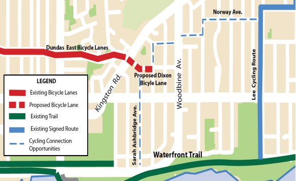
Dixon Avenue Contra-flow Bike Lane
Greg Burrell, from Ward32Spokes added this item to Ward30's Problems/Opportunities Map.
This one lays outside the boundaries of Ward 30 - but is on an important East-West cycle route that Ward 30 cyclists use all the time. The Dixon Ave Contra-flow is off the eastern end of the Dundas Bike Lanes at Kingston Road.
The Dundas Bike Lanes run through Ward 30 and part way into Ward 32 (about half-way between Coxwell and Woodbine). Dundas Street ends at Kingston Road but Dixon Road continues east from there over to Woodbine - but for car traffic-flow reasons - it's signed One-way westbound at Kingston Road for about 90 metres to Lockwood Rd - where it reverses and goes one-way eastbound over to Woodbine.
The One-way at Kingston forces eastbound cyclists coming off the Dundas Street Bike Lanes to tempt fate and take the one-way wrong-way on Dixon for 90 metres. For West bound cyclists - they aren't even aware Dixon leads to the Dundas Lanes - because they never take it off Woodbine - it's one-way eastbound at that end.
Councillor Mary-Margaret McMahon, and Ward32Spokes are working now with Transportation to get a Contra-flow on Dixon A public meeting is scheduled for Tuesday, February 18 at the Beaches Recreation Centre - 6 Williamson Rd, Toronto, ON M4E 1K5.
See: Beach Metro, "New bike lane may be coming to the Beach" http://www.beachmetro.com/2014/02/04/bike-lane-coming-beach/
Below is Ward32Spokes map of the Contra-flow proposal, and all the connections that it enables (I understand that the current process only deals with Dixon Avenue from Kingston Rd. to Brookmount Rd. - the dashed red line on the map):
@Ward30Spokes Map - Dixon Avenue Contra-flow and connecting routes (received - 2014-02-07)
Felstead Ave Filtered Access for Cyclists
Also on Ward 30's Problems/Opportunities map, in the north-east of the Ward - is Michael Polanyi's opportunity on Felstead Avenue (East off Greenwood, four blocks South of Danforth)
Felstead Ave. has a traffic island on it that prevents car access past St Patrick Catholic Secondary School. Michael asked that a Cyclist's 'Cut-though' be made in the island to allow cyclists through.
Google Map image "CycleTO Ward 30 Bikes: Problems/Opportunities" (http://goo.gl/maps/C7h9v)
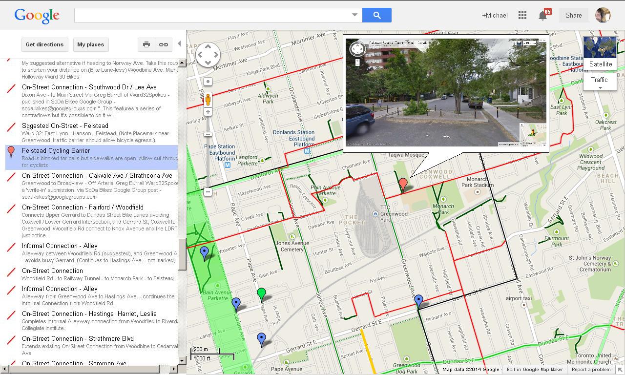
If you look at the Street View image (that I've cleverly pasted into the pop-up bubble), you can see the traffic calming island installed there.
The island was installed to prevent cars from using Felstead Ave. as a high speed through-route between Coxwell and Greenwood. That's because there is a school just out of the image to the left, a big Park to the right, and Monarch Park a block East.
Councillor Paula Fletcher has just mailed Transportation Division about our opportunity and requested a walk of the site with staff.
Councillor Paula Fletcher's Tweet from Feb 6, 2014
Working with @Ward30Bikes to get filtered access on Felstead for cyclists. #MonarchPark https://t.co/8SlJRJTfw1
— Paula Fletcher (@PaulaFletcher30) February 6, 2014
Ward 30 Bikes and Councillor Paula Fletcher are working with Transportation Division to see if we can begin a process to get a Cyclists' cut-through here.
 The Cut-through will look very much like this one on Huntley Street - in Ward 28 (South off Bloor St E. four blocks south at Earl Place (image right - cut-through on Huntley leading onto Earl Place).
The 'Filtered Access' on Felstead Ave. just doesn't make it 'nice' for kids cycling to and from school or the Parks there - is also connects important East-West and North-South Cyclist routes --- so their parents who commute by bicycle into the core everyday can stay off Danforth, Gerrard, Kingston Road and Queen Street East - which are insanely dangerous during peak hours (all the time).
The red lines on the Ward 30 Map are 'suggested on-street routes' that cyclists have added to the map. The dark green lines (see image above) are City of Toronto Transportation's 'on-street routes'. The dashed green are 'suggested informal routes' - both of which appear on the City of Toronto yearly Cycling Map. Notice how the red lines connect existing routes - and how Felstead is key to two of them.
This cut-through enables a route from O'Connor Dr. near the O'Connor Bridge in the north-east, down to the Danforth Ave at East-Lynne Park (via Woodmount Ave) that connects - via Felstead - to Broadview Ave in just below Danforth . As well, the Felstead route helps connect south - via the new Tunnel treatment under the Tracks at Monarch Park - which allows a connection to the Dundas Bike Lanes, the Lower Don Recreation Trail, and the Martin Goodman Trail - all of which are important East-West Bicycle Commute Routes.
CycleTO Ward 30 Bikes: Problems/Opportunities
View CycleTO Ward 30 Bikes: Problems/Opportunities in a larger map
We identified many ways improvements can be made:
- Identify Dangerous Street Design - so that Transportation Staff are aware of cyclists' perspective;
- Contra-flow Bikes Lanes - wrong-way lanes for cyclists on one-way streets
- Bike Boxes - to make traversing intersections safer;
- Bike Lanes - streets where we thought there needed to be separated infrastructure for cyclists;
- On-Street routes and Informal Connections - improvements along routes that cyclists were using parallel to high-speed Avenues;
- Bike and Pedestrian painted-on through-ways in huge Big-Box Store Plaza Parking Lots;
- "Fly-over" Bridges - Pedestrian/Cyclist only light-weigh structure where no On-street route is possible;
- Tunnels - places where railway and highway corridors block connections between neighbourhoods;
- Road Reconstruction - streets where the condition of the roadway makes cycling hazardous;
- Trail Intersections - crossings along Recreation Trails where the design is hazardous to cycle traffic;
- Multi-Use Paths in Parks - ways to create cycling and pedestrian infrastructure through City Parks;
- Maintenance Issues - places where Bike Lane markings were fading;
- Speed Bumps - some Tommy Thompson Park traffic calming measures were identified as hazardous to cyclists and a barrier to accessibility;
And we've plotted the fixes and issues on the map where we think solutions are needed. In Google Maps (link under map above) scroll down the left sidebar to see them all listed with a description. To see more info (and images) click on one, and a pop-up window will open on the map).
Please add your Problem Opportunity to the Map - and don't worry about wreaking it - we have back-up files to fix.
If you don't map, leave your idea in comments here - or at the two links listed in the sidebar of the map. We'll add your observations to the map for you!
mh
This comment has been removed by the author.
ReplyDelete