Showing posts with label Port Lands and South of Eastern Study. Show all posts

Friday, November 4, 2016

East Harbour (Unilever site) Update - what @Ward30Bikes is advocating for in this project


By Michael Holloway

via Toronto Star, via FirstGulf - East Harbour's Broadview extension south through a proposed Transit Hub on the rail berm - with (typical of last-century city building) missing Active Transportation visioning

East Harbour is developer FirstGulf's new brand name for the UniLever Site at Lake Shore Boulevard and Don Roadway (the Don River). With progress being made on the numerous different elements integral to this massive city centre development south of Eastern and Broadview, East Harbour has been in the news quite a bit of late.

Here's a good overview with lots of pictures:

Urban Toronto - November 2, 2016
Preliminary Plans Reveal Scope of Unilever Redevelopment
by Stefan Novakovic
http://urbantoronto.ca/news/2016/11/preliminary-plans-reveal-scope-unilever-redevelopment

I'm on the working group representing Ward 30 Bikes.

Not included in these overviews is all the active transportation infrastructure we've been talking about at ~2 years of working group meetings.

We're advocating for a way to extend the Eastern Avenue Bike Lanes west from Logan across the valley through this project.

We're advocating for an east-west corridor for bicycles from Eastern at the rail bridge along the south side of the berm (integrated into the massive Transit Hub somehow) and across the valley to connect to the Lower Don River Trail and to Corktown Common and beyond (Richmond/Adelaide Bicycle corridor).

Early designs also include a north-south route along the west side of the property and then a connection to the bridge across the valley via said transit hub (which extends from the west side of the valley to the rail underpass at Eastern).

We also want to extend the Eastern Avenue Bike Lanes west of the rail underpass to Broadview - and somehow north from there to the Viaduct near Danforth/Broadview.

Broadview is to be extended south of Eastern through the site and into the Port Lands. We see this section of Broadview as a street with high quality separated bike infrastructure on it (as does the Port Lands Acceleration Initiative report).


Image via: East Harbour: Where Toronto will go to work and play | https://www.thestar.com/life/homes/2016/05/09/east-harbour-where-toronto-will-go-to-work-and-play.html | via @torontostar


mh

Saturday, August 22, 2015

Better Placed 'Bike Rooms' needed in StudioCentre proposal on Eastern

 - to reduce the rate of increase in neighbourhood motor vehicle volumes 

Ward 30 Bikes' "Eastern Avenue Working Group" is making steady progress on our submission to City Planning about the proposed StudioCentre development on the south side of Eastern Ave between Pape and Larchmount.

From our still-in-draft report, this is a snippet about the Bike Rooms indicated on the drawings near loading docks in 5 buildings:

Bike (parking) Rooms in drawings submitted by StudioCentre are located right next to loading docks. This is the worst place to put them.

Best Practice says they should be view-able from the street like an apartments' front entrance door --- and especially not in a narrow service alley shared with loading docks and a parking garage ramp connected to the street grid via a rear roadway intended mainly for solid waste and delivery trucks.  

As an example of this (and other*) best practice - translated into a retail/office box development context, I sketched a better placed StudioCentre Bike Room on their most recently submitted ground elevation drawings (June 2015).

Full Size: https://blogger.googleusercontent.com/img/b/R29vZ2xl/AVvXsEjO9kG9_asR6DbV-fYcGxpU-I__sYvjh64_haEcZIgwyACuZioZnLAsMn6nu5C_CCpGhhNLzmEuG2Lg6hSItHgkzONZfD49pjclVTqKz43vdq24sI6wnd-uJnePJijcpd9mxZLe9hZZW3oH/s1600/Bike+Room+Placement+-+W30B+mark-up+on+developer+changes+presentation+June+2015+public+meeting.jpg


As an example, I moved the Bike Room in Building 03 (southwest corner of Eastern and new lower Caroline) such that it now it has:
  • Two sets of double wide doors right beside the main entrance to the buildings' Foyer (perhaps grocery store style sensor-opening sliding doors?);
  • Two doorways to the Foyer, one that leads directly to the elevator banks, and one that leads to the stairs (totally integrated);
  • Propose a glass street-front wall, and a glass divider wall between the Bike Room and the Foyer (this keeps 'eyes' on the Bike Room and advertises the developer's sustainable transportation amenity - which helps to create buy-in by tenants and employees);
  • Propose a washroom in each Bike Room - which should include a shower and lockers (might consider a cost effective, unisex facility: common counter and sinks; locking, single toilet rooms; locking shower room; a wall of half-high lockers).


* (and other best practice about bike parking) - separate motor vehicle spaces and bike spaces wherever possible; locate bike parking as close to the main entrance as possible; create a safe, accessible, well lit, calm egress to the amenity; create a warm, bright, visible, welcoming bike parking space - via:

City of Toronto May 2008 | "Guidelines for the Design and Management of Bicycle Parking Facilities" - ideas sprinkled through-out the report, specifically see Part 2.4.4 - Indoor Bicycle Parking (Bike Room) - p. 10 | http://www1.toronto.ca/city_of_toronto/city_planning/transportation_planning/files/pdf/bicycle_parking_guidelines_final_may08.pdf


References:

Image source: 629 Eastern Developer Changes (presentation at a June 25, 2015 public meeting at Revivals' newly renovated digital arts studio space off lower Winnifred) | http://www.studiocentre.com/images/Concept%20Plans/1120-Eastern_Av-Concept_Plan-23062015.pdf


mh

Monday, July 27, 2015

Complete Intersections in the context of the StudioCentre proposed development at 629 Eastern

by Michael Holloway
Lead - W30B Eastern Avenue working group


I created this image that attempts a close-to-scale drawing corrected to 180 degrees of the StudioCentre proposed Eastern-Caroline intersection.  The new street south is the same width as Eastern Avenue.


Eastern-Caroline Complete Intersection template.jpg


Copy it and paste it into a mark-up program (like MS Paint) and add your Complete Intersection treatment ideas - and post at the Google Doc we have up for discussion and writing of a report concerning the StudioCentre transportation context.

Google Doc - StudioCentre: Active Transportation Context | https://docs.google.com/document/d/1PvD4PFR1Cx-S0S_4oapq12YwpDE4QvEArOYuEsm1dPg/edit?usp=sharing

EMAIL Ward30Bikes and request editing permission.


The latest proposal includes bike lanes on new lower Caroline as a two-way roadway; existing Caroline remains one-way southbound with a Contraflow Bicycle Lane northbound. At the public meeting in June 2015, in a presentation by the BA Group Transportation specialist, several treatments were proposed for the north side of the intersection intended to prevent southbound Caroline motor vehicle traffic from proceeding south through the intersection (bikes excepted). The intersection is to be a signaled intersection with left turn lanes on westbound Eastern and on northbound Caroline.

Treatments of nearby intersections (Pape, Winnifred, Larchmount, Berkshire, Rushbrooke) to create connections north-south; and to better allow exits and entrances to the Eastern Avenue roadway are also a part of this process (thought we should start at the key, central intersection of the development proposal).


Michael Holloway
July 27, 2015

Saturday, July 4, 2015

Eastern Avenue Don River to Queen-Kingston - Proposed Developments Context

By Michael Holloway
Ward 30 Bikes member


In order to frame the issue more clearly, I made a Eastern Avenue Context Map.

(Full Size: https://blogger.googleusercontent.com/img/b/R29vZ2xl/AVvXsEitFmGGt5FYYkT3jQ5yE4uKc0COdL7bhSiNDJpSqXDmWYMfvVIPaN1a3fN87b7N0lQt3bIYueZL9KecocqThwUSeoTNw-4xGIcyPScurIvFLPy02NfnU3WtKk7duLae-qny6I-B8HM_Wzkg/s1600/Eastern+Avenue+Don+River+to+Queen-Kingston+Rd+-+Proposed+Developments+Context.jpg)

Together these development proposals along (so far) 3/4's of the length of Eastern Ave offer a huge opportunity for us to create a Spine Complete Street and at the same time remediate a major barrier to access to the waterfront along the bottom of our City, and our neighbourhood.

When considering the potential remember, when we talk about a roadway we must consider how it acts both as a connector and as a barrier. Right now Eastern acts as a barrier to east-west cycle traffic because it is not connected west and east, and it also is designed such that getting onto it and off of it, is extremely hazardous. Eastern acts a barrier north-south because is is a 'built-for-speed', 'move-cars-fast' designed street.

Induced traffic via the FirstGulf's Project21 and StudioCentre's developments; plus much higher residential density at the 3 now-in-process condo developments on Eastern (and several nearby on Queen St) means if left as is, Eastern will become a greater barrier, a greater hazard, than it is now.

Not to mention the fine-filtering that increased volumes will induce on the local neighbourhood streets that run off of it (also a barrier for cyclist traffic).

The TTC Russell Yards bottle-neck at Connaught to Minto is a problem and an opportunity. It could be a dangerous pinch point, or it could be the Nut of a beginning of a process of calming Eastern east of Leslie; and the beginning of a vision to create Bike Lanes east of Leslie.

Woodfield Rd is an excellent connector from the top of East York at the Cosburn Bike Lanes, and travels almost straight down to the LDRT on quiet residential streets. As such Woodfield is an opportunity to calm Eastern just west of the high-speed chicane there leading to the new pinch point at Connaught that the TTC is constructing right now.

Michael Holloway
July 4, 2015


mh

Tuesday, April 14, 2015

Lost Rivers of East Toronto mark possible Canals on the Port Lands; Connect the City to the Lake


I've done more work on the “Canals on the Port Lands” idea that I represented during the July 23-24, 2014 Shipping Channel Charrette organized by City Planning - and in all the phases of the Port Lands Acceleration Initiative (PLAI) public consultation process.

The idea is to pinpoint the most effective and sustainable starting points and routes of possible bioswale-edged, open-water canals extending from the existing flow basins north of Eastern Avenue, and extending them south down to the lakefront such that they mimic natural water courses (that still exist in stratification under modern fill) as part of a storm-water/water-table management system on a redeveloped Port Lands and nearby environs.

This storm water management system would be associated with Green Streets and could then be developed as transportation corridors (including connection points for swing-aside, floating bike bridges across the great barrier to north-south transit, the Shipping Channel), and many other recreational opportunities - and - would be a landscape feature that would greatly increase the sense of well being and general health of existing and planned communities in the Port Lands and environs.

This new feature will also greatly increase the value of those lands via the features' visual magnificence. As well, bioswale-edged, open-water canals would completely remediate the Port Land's brownfields (toxic, polluted land) over time.

This storm water management system would reflect the natural history of this place; and this is essential in this era of rising global temperatures and the effect that has in increasing the rate of extreme storm events which will cause storm-surge cresting in Toronto's (now mainly buried and redirected into sewers), natural drainage flow-ways.

The Process of Discovering the Buried Rivers of East Toronto

Since the Shipping Channel Charrette I've done walks of an area bordered by the Don River, Hogarth Ave, Woodfield Rd and Lake Shore Boulevard. Focusing on the landscape proximate to Eastern Avenue, I have aimed to understand the coarse of these river under the modern street grid from their mouths on the historical Ashbridge's Bay all the way to their headwaters - often well north of Danforth Avenue.

I've used historical research, landscape observations; historical maps; historical Ashbridge's Bay depth sound maps and historical and modern contour maps.

These creek and river valleys reveal paleontological underground topographic forms created by run off in the last ice age (as well as glacial scraping) now buried under more recent sedimentation and later modern fill, in the South of Eastern area of the Port Lands Acceleration Initiative (PLAI) study area.

The Post-Glacial Drainage System of Toronto

The topography of Toronto is characterized by flutes in the landscape that run from northwest to southeast.

These flutes were formed as the Laurentide Ice Sheet retreated towards the northwest in this region about 13.000 years ago. The run off from this late phase of glaciation in the last ice age created these flutes that are arranged approximately 1 km apart across the southern Ontario region. They are evident on the landscape still - even under the urban built form and street grid layered on top of them. They can be seen on the landscape as a series of rises and valleys we know as the Ravines.

Map of Flutes and Drumlins in West Toronto
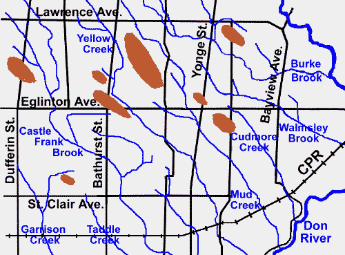
(Via Lost Rivers - http://www.lostrivers.ca/content/points/drumlins.html)

These ravines are a fingerprint of the last glacial age, and mark the beginning point of the re-creation of the living biosphere here - and coincidentally, the re-habitation of this place by prehistoric humans. As such, they are key to the historical culture of this place and the future sustainability of development in this place.

The Ancient Creeks and Rivers of the South Riverdale Drainage System

On an historical contour map of East Toronto from 1921, I've drawn in blue lines along routes which the contour lines indicate are valleys in South Riverdale. I've also added labels along the left and bottom edge of this map to indicate the approximate position of the modern street network.

(Via University of Toronto Libraries - Don Valley Historical Mapping Project - Contour map of Toronto district - Lazenby, Paul H.; Toronto Transportation Commission,1921 - Call Number: G3524.T6 C222 19 1921 R - http://maps.library.utoronto.ca/dvhmp/maps.html)
(Disregard the furthest east conjecture - that one's just wrong.  :)

The best modern contour map I could find of East Toronto is from the Natural Resources Canada, GeoGratis (v2.0); Search: "Toronto, York, Ontario (City)", Subject Keywords: "contour, map,". The image below is a cropped version of the pdf contour map of Lake Ontario bottom, which includes a base map of Toronto that has a fairly good modern contour grid on it.

Toronto, Lake Ontario | http://ftp2.cits.rncan.gc.ca/pub/geott/ess_pubs/123/123145/gscgsm_8412G_b_1987_mn01.pdf

To better pinpoint the location where these rivers and creeks drained into historical Ashbridge's Bay, I used this depth sound map from 1912 that shows the depth of the Ashbridge's Bay swamp at various points measured using a sounding weight. These depth measurements allow one to understand the underwater (now under landfill) soil stratification as well as the various flow rates of the rivers and creeks.

Via University of Toronto Libraries - Don Valley Historical Mapping Project - Toronto Harbour Commission, Waterfront Conditions 1912,  E.L. Cousins, Chief Engineer & manager; Toronto Harbour Commissioners, Call Number: G3524.T621 24 1912 - http://maps.library.utoronto.ca/dvhmp/Scans/G_3524_T621_24_1912.jpg)

A recent TRCA contour map shows the regulatory flood plain north of the Port Lands in the South of Eastern area (Spill Zone 2). One can see low points (contours that drive north of the general latitude of the flood plain's northern border) where ravines once likely ran with rivers.

The map shows multiple ravines near Jones, Rushbrook and Curzon indicating possible canal route at Leslie St on the Port Lands; at Geenwood, Highfield, Woodfield and Hiawatha a series of ravines indicate a possible canal in the South of Eastern area south of Jonathan Ashbridges Bay Park, and then south just east of Coxwell Ave down to present day Ashbridge's Bay.

Softer juts north (likely due to high amounts of landfill/landscaping) indicate valleys at Heward, Pape/Winnifred, Caroline/Larchmount - indicating possible canal route along the east side of the Turning Basin on the Port Lands. Contours of the flood plain  indicated by long dives northward at Lewis and Saulter indicate another possible bioswale-edged, open-water canal at near McCleary Park on the Port Lands.

TRCA - Lower Don River Regulatory Flood Plain - Spill Zone 2 Diagram
TRCA - Lower Don River West Remedial Flood Protection Project Environmental Study Report | p. 1 - Figure 1.1 - Regulatory Floodplains along the Lower Don River (http://www.trca.on.ca/dotAsset/25780.pdf)

With the aid of a 1902 Map of East Toronto that indicates the position of valleys and rivers at that time ...

Villiers Sankey Map of Toronto 1902_G_3524_T61_1902 - University of Toronto Libraries - Don Valley Historical Mapping Project  - http://maps.library.utoronto.ca/dvhmp/maps.html)

.. I have transposed the position of the now underground rivers which once flowed into the Ashbridge's Bay lowlands onto a Google Map which includes a modern street grid layer. These four sources layered together provide a very accurate picture of where the lost rivers of East Toronto run under the modern built form, and where they drained into historical Ashbridge's Bay.

South Riverdale Drainage System Google Map

View South Riverdale Drainage System in a larger map

(This is an ongoing project - walking the neighbourhoods to identify the valleys under the street grid is essential to understanding the paths of these rivers under landfilled urban built form - to date (April 2015) I have walked the entire extent of the Caroline/Larchmount River, the Leslie Grove Park River; walked the south of Danforth section of the Greenwood Brickworks River, and south of Gerrard section of the Ashbridge's Creek - thus - at the time of this publishing, lines on the Google Map outside of these walked areas might not be particularly accurate.) 

The light Blue line is the planned extreme crest spillway for a naturalized mouth of the Don River. The north-south avocado-green line represents a PLAI vision - a 'Green Gateway' to the beach on Cheery Street below the lift bridge. The two east-west avocado-green lines represent PLAI's visioned bioswales along those roadways.


To this point (April 2015) I have walked the street grid attempting to identify the coarse of the following rivers and creeks (I've named them, or where historical sources provide, used those names): 
  • Caroline/Larchmount Creek* (headwaters starting in the Millbrook Crescent/Ingram Ave  hollow - and a tributary under Withrow Park; down to Carlaw/Gerrard, under Dundas/Boston Ave, Queen/Pape and into Historical Ashbridge's Bay at Eastern between Caroline and Larchmount - currently, modern landfill that makes up the back lot of Revival 629 Movie Studios shows evidence of the river under ground there continuing south to the Lower Don Recreation Trail  - I believe the Lake Shore Boulevard acts as a dam at that point, which has created wet topography there which is supporting a grove of willow trees);
  • Leslie Grove Park River (Wroxeter/Pape, under Gerrard Square, Marjory Ave, Leslie Grove Park and entering historical Ashbridge's Bay at Eastern/Leslie St - under Loblaws' north parking lot - which is landfill); 
  • the southern reaches of Greenwood Brickworks River (Sammon Ave/Donlands, under The Only Cafe at Danforth, Phin Ave Park, the TTC Greenwood Yards, Greenwood Park, Maple Leaf Forever Park and into ancient Ashbridge's Bay at Eastern Avenue); 
  • and the south reaches of the Ashbridge's River (starts under Greenwood Secondary School, and a tributary under Robertson Parkette - 1549 Danforth, west of Coxwell/Danforth - then under Monarch Park Collegiate Institute, Hiawatha/Gerrard, Dundas near Highfield Rd, under Duke of Connaught Junior/Senior Public School, S.H. Armstrong Community Centre, under that huge willow tree in Ashbridges Estate Park - 1444 Queen Street East; and then under TTC Russel Yards to Eastern where it drained into historical Ashbridge's Bay).
_________

* What I'm calling the Caroline/Larchmount Creek, "Lost Rivers" website is calling the Heward /Holly/Mill Brook Creek.

From Schedule of Planned Walks (accessed April 2015):
Sunday, February 15, 2015, 2 pm – Mid-Winter Walk in Riverdale: Heward /Holly/Mill Brook. From Leslieville to Playter Estates, we’ll tour the first major lost creek east of the Don. Long buried, this stream with several names once scored the landscape, creating the contours of Withrow Park. And it inflected our narratives of the East End, from brick-works and needle trades to coffee shops and dog parks. John Wilson and Joanne Doucette (author of Pigs, Flowers and Bricks: A History of Leslieville to 1920) invite you to share neighbourhood scenes and stories. Meet at Queen and Pape; end at Carrot Common near Chester subway station.

See my Google Map, "South Riverdale Drainage System" to check out the routes of these and more East Toronto Lost Rivers (also embedded above).

A Dialectic of Benefits

These water coarse would be positioned starting where historical rivers and creeks once flowed across the landscape - as these natural geological places mark low points in still existing drainage basins - now under unstratified fill.

This specific bioswale-canal placement will help drain storm water in the most efficient manner possible; an important consideration when understood within the context of higher than normal lake levels and a higher rate of extraordinary flood events due to apparently, unabated human caused, carbon loading of the atmosphere which is leading to warmer global atmospheric temperatures leading to glacial and polar ice cap melting.

Alongside these bioswale edged canals might be constructed "Green Streets" - which drain their storm water into the proximate 'new-form' storm water drainage infrastructure. These green streets are key in the lowland Port Lands area as sewer systems will need to be above the lake level - plus, this kind of storm water management is much cheaper than conventional storm water management systems using buried pipes. As well, this bioswale canal storm water management system would be much cheaper to maintain than conventional systems.

New Green Streets roadways would parallel existing (currently underground) water courses (which define the most effective locations for a bioswale coarse) which are in turn, defined by low points in the natural drainage basins - which are identified by the known coarse of historical creeks and rivers.


Images of a Green Street Construction technique - from Land8 | http://land8.com/group/greenstreets

In some cases this approach might present opportunities to extend these bioswale edged Green Streets north of Eastern into the existing neighbourhoods - which would dramatically increase the value of these properties - both in that drainage would be better and thus ground water levels would be consistently lower (thus less or no basement flooding) and the effect of the resulting green spaces would increase the value of the land in a spiritual sense - homes adjacent to, or with a view of these bioswale canals, would accrue in value in the market place.

The new-form water management infrastructure would create a lower water table and reduce (perhaps eliminate) instances of wet basements and flooding in the existing urban built form there; thus increasing land values and development opportunities just north of Eastern Avenue - land that has had historically depressed value compared to nearby land on slightly higher elevation.

This base infrastructure on the Port Lands proper would at once create visual benefits, transportation, recreational opportunities, livable neighbourhoods, health and well being, plus brown-field decontamination and higher land values immediately as well as increasingly over the long term.

I believe that in order for this concept to be effectively deployed it has to be a prominent feature in the Port Lands and South of Eastern Transportation and Servicing Master Plan.

I have tried to include these ideas - only in their infancy at the time - over the two days of the July 2014 PLAI Charrette; but also in my web submission after attending the first public consultation in the fall 2013 - the "Port Lands and South of Eastern Public Meeting #1" (November 28, 2013, at Riverdale Collegiate).


Mapping these ideas:

More on these natural water coarse as part of a transportation visioning for short, medium and long term connections from the neighbourhoods to the waterfront - all plotted on a Google map with the map's Place Mark notations listed in the blog:

Ward 30 Bikes - Thursday, July 24, 2014 | 'Idea Mapping' the Shipping Channel Charrette | http://ward30bikes.blogspot.ca/2014/07/the-shipping-channel-charrette-july-23.html


Bioswale Links:

OMSI Parking Lot Swales - The City of Portland, Oregon [PDF] | https://www.portlandoregon.gov/bes/article/78489

Sustainable Horticulture | Green Streets/Bioswales/Rain Gardens | http://www.sustainablehort.com/?p=177

United States EPA | What is Green Infrastructure? / Bioswales | http://water.epa.gov/infrastructure/greeninfrastructure/gi_what.cfm#bioswales


PLAI Links:


Port Lands Acceleration Initiative: Home | http://www.portlandsconsultation.ca/

Port Lands Planning Framework, July 23-24 2014 Charrette Summary | http://portlandsconsultation.ca/sites/all/themes/portlands/files/Port%20Lands%20Charrette%20REPORT.pdf


Michael Holloway
Resident, Leslieville, Toronto
Member, Ward 30 Bikes,
Cycle Toronto
PLAI SAC


mh

Wednesday, May 28, 2014

South of Eastern Strategic Direction Public Consultation Meeting talks about High Rises at Lever, Big box at Revival and Eastern Avenue as a Calmed Neighbourhood Street

[2014-05-29 - Edited to better reflect the ongoing discussions on this issue with-in the Ward 30 Bikes group]

Ward 30 Bikes attended the South of Eastern Strategic Direction Planning Public Consultation meeting at Ralph Thornton Centre, Tuesday, May 27, 2014.

About 60 people participated including 3 members of Ward 30 Bikes. This meeting came right on the heels of our Active Transportation Stakeholder meeting with the Study Team last Thursday - where we went into fine detail about our concerns with regard to building connecting Greenways north-south & east-west through the South of Eastern Study area, Broadview - Eastern - Coxwell - Lake Shore Boulevard.

Lots of talk at the Public Consultation Meeting about Eastern Avenue.

With proposed and projected developments in the area, we are at a stage where we will either lose the Eastern Avenue Bike Lane - or expand it so it goes the distance and also connects neighbourhoods.

One table at the Public Consultation Tuesday evening came up with a brilliant idea: Creating Filtered-Accesses at Queen/Kingston and at Eastern/Broadview - to prevent the roadway from being used as an commute alternate to the Lake Shore Boulevard (LSB). In other words - making Easter Ave a Neighbourhood Street rather than a Scarborough/Downtown suburban commute choice.

Also much talk about the Great Gulf plan for the old Lever site which proposes a new downtown core there - with 3 million square foot of office tower floor space.

(Which this Ward 30 Bikes member believes would be the beginning of the end of the residential character of the South Riverdale, Riverside and Leslieville neighbourhoods - and would very likely lead to high-rise development in the Port Lands as well ... a place for the 'Big Pool of Money' to expand that high-rise Lake Front development that they have going on in the West-Lake-Front-Core - now possibly expanding East.)

As well we talked about the character of the other proposed development in the study area - the StudioCentre with it's retention of the Film Studios - but also adding 1,100-2,400 parking spaces stack in three stories above glass facades that will serve a 10 story Hotel as well as a Big Box Store sized square footage of "Flex Space" --- which some interpret as a, 'WalMart by any other name').

In this "Liveable Cities" advocate's opinion, the idea of Filtering Access to Eastern Avenue is a great idea. Eastern could become a "Green Buffer" between the employment district and the neighbourhoods to the north of it.

We image lots of connections through the study area north-south to the new Port Lands neighbourhoods - and a 'Calmed' Eastern Avenue --- with Mass Transit, Green Spaces, Wider sidewalks, Narrower traffic lanes, Bump Outs at many corners, Pedestrian Crossings (especially at the chicanes at Rushbrooke and Woodfield), and Separated Bike Lanes from Queen/Kingston to Broadview ...

.. And then, east-west up and over the Don Valley Parkway and the Don River - either by a radical reconfiguration of the Eastern Avenue Bridge (re: Highway Overpass 'Death-Ramp') or via a Pedestrian/Cyclist Fly-Over Bridge at Sunlight Park Rd that uses the existing unused Bridge over the river as a landing point for a two-arc fly-over that will connect South Riverdale to the new Corktown Common Park - and the Lower Don Trail connection there (through the new tunnel under the rail right-of-way at the eastern mid-point of the Park ... The Corktown Common Park is gorgeous by the way - check it out!).


mh

Wednesday, May 21, 2014

South of Eastern Strategic Direction: Active Transportation Stakeholder's Consultation

South of Eastern Strategic Direction: Active Transportation Stakeholder's Consultation
Thursday, May 22, 2014
Ralph Thornton Centre (765 Queen St. East)
Basement Room
6pm - 8pm

@Ward30Bikes had a short conversation on Twitter with the planningAlliance last Fall -


Since then the South of Eastern Strategic Direction planning team (and the planningAlliance team members) have been working to find time to create a meeting where Cyclists on the East Side could sit down with Planners and expand our concerns and visions for the future of our neighbourhoods.

Tomorrow the Planning Team will hold a Cyclists and Walkers Stakeholders event where they will present their narrative so far - and ask for our feedback and new ideas.

The planningAlliance has already studied our Problems Opportunities Mapping Project - and included some of our ideas into the draft report. Tomorrow they're looking for your personal observations - that aren't on the map - or - perhaps included in the report but not fully representative of what you meant to say in your map submission.

Have you thought further about possible new development proposals in the study area that weren't on your radar 6 months ago?

Like:
  • A better fleshed out StudioCentre plan?
  • The Weston Bakery proposal?
  • First Gulf Corp's 'Second City Centre' proposal?
  • What a Second City Centre might mean for the future of the Port Lands?


mh

Tuesday, May 6, 2014

Active Transportation/Livable Cities - Stakeholder Workshop

South of Eastern Strategic Direction - Resource List and Discussion Primer:

Resource List

Official Documents


City of Toronto | City Planning | Community Planning | Toronto and East York District | South of Eastern Strategic Direction | https://www1.toronto.ca/wps/portal/contentonly?vgnextoid=8f6692540e1c4410VgnVCM10000071d60f89RCRD&vgnextchannel=4b4452cc66061410VgnVCM10000071d60f89RCRD

Links listed at the 'South of Eastern Strategic Direction' link.

Active Development Applications

Here is a list of active development applications in the South of Eastern Area

629, 633 & 675 Eastern Avenue

(at the "629, 633 & 675 Eastern Avenue" link)
Supporting Documentation
Plans and Drawings                                     Jan 21, 2014    Download
Planning Rationale                                     Jan 21, 2014    Download
Environmental Impact Study                             Mar 12, 2014    Download
Transportation Impact Study                            Jan 21, 2014    Download
Arborist/Tree Preservation Report and/or Declaration   Jan 25, 2014    Download


A Community Consultation Meeting was held for this application on January 27, 2014.

629, 633 & 675 Eastern Avenue Preliminary Report
629, 633 & 675 Eastern Avenue Community Consultation Presentation
629, 633 & 675 Eastern Avenue Community Consultation Meeting Notes


459 Eastern Avenue (Official Plan and Zoning By-law Amendment)

A Community Consultation Meeting date has not been scheduled for this application.
462 Eastern Avenue (Official Plan and Zoning By-law Amendment)

A Community Consultation Meeting date has not been scheduled for this application.

More Generally...


Port Lands Acceleration Initiative (all the links to all the Study Documents) | http://www.portlandsconsultation.ca/
 

Ward 30 Bikes Outreach

Google Maps | CycleTO Ward 30 Bikes: Problems/Opportunities | http://goo.gl/maps/C7h9v 

Ward 30 Bikes label: "South of Eastern Strategic Direction" | http://ward30bikes.blogspot.ca/search/label/South%20of%20Eastern%20Strategic%20Direction

A Discussion Primer:


How do the major Avenues in the South of Eastern Study Area; LSB, Eastern, Carlaw, Leslie and Coxwell relate to each other and to the neighbourhoods of Ward 30 and Ward 32?

A vision of their functioning - an article (the essence of which was outlined at Ward 30 Bikes monthly meeting on May 6th):

Ward 30 Bikes | The Amazing Shift - Eastern Avenue draws commute traffic into Riverside, Leslieville, South Riverdale - via Leslie and Carlaw from Lake Shore Boulevard | http://ward30bikes.blogspot.ca/2014/05/the-amazing-shift-eastern-avenue-draws.html


Connect the City to the Lake


Vision 1

One vision presented at the May 6 meeting was of creating many, many crossing points south across the LSB. This is reflected in the Port Lands Transportation Plan. The crossing points being considered are one of the four streets just west of Leslie (Rushbrooke, Berkshire, Larchmount, Caroline); plus Carlaw, Logan and a new street, an extension of Broadview down to Bouchette Ave (west side of McCleary Park) and the Don Roadway. The idea is this would bridge the Lake Shore Boulevard and create north-south connectivity through well designed intersections across it.


Vision 2

I have  problem with the vision above. I don't think it will solve the barrier problem.

Signal phasing will enable the high speeds that the Lake Shore Boulevard is built for (built for 100km/h speeds - signed at 60km/h - but does 80-100km/h most of the day). Unless we reduce the Boulevard to a regular Avenue - it will remain a barrier of speed and noise and width - and attract the business models we see at Leslie and LSB - and planned at 629 Eastern (creating a new Caroline south of Eastern and a new intersection at LSB).

These business models create a traffic "nexus" at the intersections where they are located. The entire intersection area becomes a barrier to active transportation and eventually (via the motor vehicle congestion it also creates) a barrier for all modes. (see Leslie and LSB; see Carlaw and LSB).

The political will to reduce the LSB to an Avenue is not on the horizon.


Instead of focusing on what the Grand Boulevard is doing, this vision focuses on Eastern Avenue. Calm Eastern in order to help create a buffer between the Employment zone (which is likely going to be all about cars) and the neighbourhood by making Eastern Avenue a Complete Street. This calming of Eastern will stop pulling traffic up from LSB onto an avenue/expressway (Front/Eastern/Kingston Rd ---> Scarborough. This will calm the north-south Streets that intersect with LSB, and allow us to create Greenway Routes accoss the Great Barrier to the Waterfront.

To Complete Eastern Avenue - narrow the traffic lanes add buffered bike lanes; create the widest possible sidewalks all along it. Add better setbacks where possible (as suggested at the 629 Public Consultation meeting on January 27, 2014 - about the 'Back Lot' concept - several suggested that the 'Back Lot' be moved out from amidst the buildings where it would be a policing issue, and bring it out to face the neighbourhood along Eastern Avenue).

Thus, a calmed Eastern becomes a collector from Broadveiw all the way over to Kingston Rd for Greenway links to it north-south: at Broadview Logan, Rushbrooke/Berkshire, Knox, Woodfield and at Jonathan Ashbridges Park and the system of Parks there - and points East and Northeast via On-street Connections and Informal Routes though Woodbine Heights to Scarborough.

By making Eastern a Complete Street we thus lessen the pull on traffic up from Lake Shore via north-south neighbourhood streets up to Eastern Avenue as an high speed avenue/expressway to Scarborough

This will lessen the pull at a proposed new Lower Caroline, as well. Thus the proposed separated bikeway through the planned StudioCentre (just to the East of new lower Caroline) works as part of the Greenway network also.

This vision allows businesses to cross the Lineal Park (the LDRT runs along it) as a trade off for the over-all good that it accomplishes.

What's YOUR vision?


Please add another vision in comments.


mh

Saturday, February 15, 2014

"Nothing short of everything" - i hate my life; I hate this thing

I've been through planning.

What I saw is democracy filtered out reality.

Here's the thing:

The Tragically Hip: "Now For Plan A"
Sounds like Eno. Bigger.
If we plan to plan out of hell - will the hell we live in be the opal we see out through?

Nothing short of everything.


Pablo Neruda (1904–1973) http://memory.ucsf.edu/blog/june-poems-of-the-month-683/


OK

I fogot there's good too. And a lot of it.

Lets just see what tomorrow brings.

Wheat Kings


Bobcaygeon


The Tragically Hip - 'It's A Good Life If You Don't Weaken'


mh

Tuesday, February 4, 2014

Queen St., Logan, Port Lands, South of Eastern, Dundas/Carlaw Corridor - a walk-about to discover North-South Cycling Opportunities

Learning through reading, walk-abouts and writing: Bouchette Street, Logan Avenue & Carlaw Avenue --- Commissioners to Dundas


I did a walk-about of the 'South of Eastern Employment Area' in a corridor which includes Carlaw Ave, Logan Ave - and south of Lake Shore, a possible connection from Broadview - Bouchette Street. My walk-about started at Queen Street and Logan, down to McCleary Park and then Bouchette Street to Commissioners. I returned to the neighbourhood via Carlaw from Lake Shore up to the Dundas Bike Lanes.

The map below shows the southerly route in green, and the return trip in red. The purple line is: 'Jeez! I wish that on the way back I had continued east on Commissioners for one block over to Carlaw and the Turning Basin!'  (click on place marks and lines for more route data and short narratives).


View Walking the Port Lands Planning Precincts in a larger map

I was looking for a way to create a North-South Cycling Corridor - as many have suggested a need for this in our Problem/Opportunities outreach to the East Side Community (see CycleTO, Ward 30 Bikes - Problems/Opportunities Map: http://goo.gl/maps/Musw4).

Here' my walk about route Friday December 13, 2013 - on an image of the Port Lands Master Plan pedestrian/cycling map. My walk-about route down is in Green - back up is in Yellow (extending up to Dundas St East).
City of Toronto Planning - Transportation and Servicing Master Plan - Page 5 of 9 - Pedestrian/Cycling Network Map (top of the map is about half way to Queen St.)
(Note how I tried to cross Lake Shore Blvd. at rush hour - bad idea - getting to the median at 5pm was easy, but then I couldn't get across the eastbound lanes no matter how long I waited it seemed. Eventually I decided I had to walk on the median east from Logan to the lights at Carlaw - but saw a walking opportunity, and crossed through grid-locked traffic, about a football field's length from the lights.)

These connectivity issues are being addressed by City of Toronto Planing in their "Transportation and Servicing Master Plan" study - a part of the "Port Lands Acceleration Initiative" - an over-all planning process for the Port Lands and the South of Eastern Avenue area which extends from the Don River over to about Coxwell and down to Unwin Avenue.

To connect the Port Lands and the Waterfront to the city, I'm also exploring north of Eastern by walking it, and reading the Dundas/Carlaw Corridor Study Documents (see link below) - and then also I intend to walk up to Riverdale Ave (just below Withrow Park) - above which the cycling / pedestrian conditions become much better. (There are issues - but those for another post.)

There's a lot to digest in these five Port Lands studies - so I'm making my way through the Transportation and Servicing Master Plan documents first - and at the same time walking the connection routes through the study areas - and - writing up my learning and understandings gleaned from the process as I go.

___________________


Below is an image I produced from City of Toronto Planning, Transportation and Servicing Master Plan, page 5 of 9 - zoomed to 800% - showing part of their proposed Pedestrian/Cycling Network that this article focuses on: Contra-flow Bike Lanes on Carlaw and Logan - intended to connect the existing neighbourhoods to the new Port Lands and to the Waterfront.

City of Toronto Planning  - Transportation and Servicing Master Plan - Page 5 of 9 Zoom -  Pedestrian/Cycling Network - Contra-flow Bike Lanes on Carlaw and Logan below Eastern

On Logan Avenue the Master Plan suggests a One-way with a Contra-flow Lane and On-street Parking.I'm not particularly fond of Contra-flows as we have designed them so far, they are not intuitive (plus one feels like car drivers don't understand it - don't expect you there. Perhaps paint on the street is a fix). So when I did my walk I was imagining either painted on Bike Lanes or a separated Cycle Track along one side.

I started my walk at Queen Street East and Logan Avenue at about 4:30pm (rush hour is just beginning to peak into grid lock). The street seems quite narrow (is it? - tape measure next time), so to add a North-South Bike Route to the street it was either make Logan Ave a One-Way and put in a Contra-flow Bike Lane - or maintain the two-way street, narrow the lanes and add a separated Cycle Track on one side, and keep On-Street parking on the other.

I'll leave out South of Lake Shore for this post - it's a whole different thing. At this time I'm more concerned with how we are going to connect to it, rather than how we may wish to develop it - except to say -  visioning 30% active transportation - aka Complete Streets.

Coming back up I took Carlaw. Carlaw is one of five "Gateway" to the Port Lands - since it already goes across Lake Shore Boulevard. Plans in 2010 and 2012 have always included this and a possible extension with a bridge south of the turning basin. So Lake Shore to Eastern I imagined Carlaw with wider sidewalks; narrower lanes and a Cycle Track along the West side - with on-street parking on the East side. Or - Bike Lanes on both sides - which means no on-street parking (lots of push-back there).

Same goes for Carlaw Ave below Eastern. It seems very uncomfotable walking there - especially on the west side sidewalk at Lake Shore. On the East side sidewalk planners have already installed a Complete Streets deep corner that feels a whole lot safer.

Continuing up Carlaw the sidewalks are really narrow and the buildings seem to almost brush your shoulder as you're walking.

I was thinking wider sidewalks two car lanes and a cycle track on the West side - perhaps On-Street parking on the East side if there's room - but I doubt it.


Above Eastern Carlaw Ave seems to open up a little - I imagine a Cycle Track along the West side of the street - two lanes for cars and On-street parking on the East side of the street.

Placing the Cycle Track on the West side of Carlaw works nicely with Morse Street Public School - kids (and their parents) should enjoy (be relieved) having the cycle track take them right to their schools' front door.

Bike Parking Amenity and Car Parking at Morse Street Jr. Public School - looking South from the middle of Carlaw - just South of Queen

Morse Street Jr. Public has a 30-car Parking Lot just South of the building. Just to the North of the car park beside the driveway for the parking lot is an aging, rusted bike rack of bad design (not useful if you want to lock your back wheel). The contraption sits tilting slightly, amidst weeds growing through the cement on the border of a collapsing textured area near the rear doors of the school.


Image - City of Toronto Transportation Services, Bicycle
Infrastructure Unit - Queen Street West Bicycle
Parking Study Slide Deck (page 15 of 20)
As part of my visioning here I see losing one-third of the car parking and installing a canopied bike parking amenity on the parking lot area closest to the school - narrowing the driveway to the lot so cars cannot use it and make that the entrance-way for bikes. The car park entrance can come from the alleyway to the South.

From here walking North you come to Queen Street and the beginning of the Dundas/Carlaw Corridor Study Area. Again it looks like the same Cycle Track on the West side. The sidewalk on the North-west corner has been widened to accomodate the Bus stop - this area feels good.

I believe Planners at the T&EY-CC Planning Workshop have imagined wider sidewalks up this side of Carlaw here. (Phase One of the Dundas/Carlaw Corridor Study is completing now - another Public Workshop is scheduled in January 2014 - Documents at Councillor Paula Fletcher's website: http://paulafletcher.ca/discover-ward-30/community-planning/#carlaw

The building under construction just above Colegate Ave on the West side has created a raised fronting that will allow sitting there. This structure looks to allow the sidewalk to widen to the comparable width to that of the Bus Stop area at the corner to the South at Queen. The Dundas/Carlaw Corridor Study also suggests Colegate gets a Complete Streets treatment - narrowing the roadway and expanding the sidewalks as an pedestrian friendly corridor West over to Jimmy Simpson Park.

The East side of Carlaw through here feels like a wall. The sidewalks need to be widened here. I suggest losing a lane and adding trees and seating amenities.

There is a break between the two long street fronts (between 239 & 345 Carlaw) that could add to the illusion that the wall of existing built form is broken up; for example a big tree pushing out into the street-view looking South would do it. Also the hydro lines running along the street on the east side add to the lineal 'wall effect' and could be buried when the street is reconstructed.

The Canyon Effect on the East Side of Carlaw looking South from in front of 245 Carlaw - arrow shows alleyway between 235 & 245 Carlaw - break sight lines by burying wires; shaped steel lattice-work between buildings with ivy; large sculpture; colour ...
___________________


That's  it for now.

I'll scout Logan and Carlaw below Lake Shore Boulevard next. My walk along the south side of Lake Shore Boulevard and down Bouchette Street and a little West on Commisioners on Friday the 13th was Really interesting! But I'll save that for a South of Lake Shore Boulevard Connections Opportunities post - next time.

After I've thoughly scouted this corridor south - I plan to walk Boothe Avenue - which looks really interesting on the map.

What's that massive CineSpace Film Studios building doing there? Is there a route through the property? What are the Planners thinking about that? Is that company going to move south into the Film Studio Precinct someday?

Is Bouchette Street a possibility for a North-South crossing of the Grand Boulevard after the Eastern Gardiner Study recommends flattening that structure that ends there?  What about the extension of Broadview down below Eastern? What of a Bike Trail by the Don River there?

Then I take Logan up to Riverdale Ave - and then scout down the Pape-Riverdale-Carlaw corridor and back down to Dundas at Carlaw again.

___________________


Links, References


Port Lands Acceleration Initiative (all the links to all the Study Documents) | http://www.portlandsconsultation.ca/


Ward 30 Bikes | Bike Infrastructure BIG Talking Point at Public Consultation for Dundas/Carlaw Corridor Planning Study | ward30bikes.blogspot.ca/2013/10/bike-infrastructure-big-talking-point.html

City of Toronto Transportation Services, Bicycle Infrastructure Unit - Queen Street West Bicycle Parking Study | http://www1.toronto.ca/wps/portal/contentonly?vgnextoid=60400995bbbc1410VgnVCM10000071d60f89RCRD&vgnextchannel=4655970aa08c1410VgnVCM10000071d60f89RCRD

City of Toronto Transportation Services, Bicycle Infrastructure Unit - Queen Street West Bicycle Parking Study Slide Deck | http://www1.toronto.ca/staticfiles/city_of_toronto/transportation_services/cycling/files/pdf/draft3_bike_parking_study_oct8.pdf


Wednesday, December 11, 2013

My Workbook submission as per the Port Lands and South of Eastern Study


Below is a cut-and-paste of the online "Participant Workbook", a digital version of a hard copy version provided to participants at "Port Lands and South of Eastern" Public Meeting #1:
Port Lands and South of Eastern
November 28, 2013 Public Meeting
Riverdale Collegate 1094 Gerrard Street East
City of Toronto Planning - WaterFront Toronto - Toronto and Region Conservation
 Below the the cut-and-paste are my submissions which were originally written in under each numbered Question in the online Workbook.

Online Participant Workbook: http://cityoftoronto.fluidsurveys.com/s/Port-Lands-and-South-of-Eastern/

Hardcopies are available via Ward 30: Toronto-Danforth Councillor Paula Fletcher's web site here: http://paulafletcher.ca/discover-ward-30/community-planning/#portlands


_______________________


100%

Participant Workbook

Port Lands and South of Eastern

This is your opportunity to provide feedback and suggestions on the new studies being initiated for the Port Lands and South of Eastern area. Your responses may be as brief or as detailed as you like and you may choose to skip some questions.

Participant Workbooks must be completed by December 12, 2013.

OVERVIEW OF INITIATIVES
Port lands Planning Framework
At 356 hectares, the Port Lands are a tremendous redevelopment opportunity for the City. Waterfront Toronto and the City of Toronto are developing a planning framework for the Port Lands that builds on the momentum from the Port Lands Acceleration Initiative adopted by City Council in 2012. The planning framework will guide revitalization efforts in the Port Lands and will provide the foundations for affirming and refining the vision for the Port Lands in the Central Waterfront Secondary Plan


Precinct Planning
Precinct planning is being undertaken by Waterfront Toronto and the City of Toronto for Cousins Quay and the Film Studio District.  Precinct Plans outline development principles and guidelines at a more detailed level and illustrate how lands can be developed to meet the policies of the Central Waterfront Secondary Plan. Precinct planning forms the bridge that allows the City to move from Secondary Plan policies to Zoning By-law provisions.
South of Eastern Strategic Direction
The City of Toronto is undertaking the South of Eastern Strategic Direction that will build upon the South of Eastern Planning Study completed in 2008, which resulted in proposed amendments to the Official Plan and Zoning Bylaw.  The Strategic Direction will focus on economic development, urban design and transportation.
Port Lands and South of Eastern
Transportation and Servicing Master Plan EA

The City of Toronto is undertaking a Transportation and Servicing Master Plan (TSMP) for sections of the Port Lands and South of Eastern area in accordance with the requirements of the Municipal Class EA.  The TSMP will identify the necessary infrastructure (streets, transit, watermains and sewers) to support revitalization in the Port Lands and continued economic growth in the South of Eastern area.

Please indicate which of these initiatives are of interest to you?

  • X
  • X
  • X

PORT LANDS PLANNING FRAMEWORK QUESTIONS


      PORT LANDS DRAFT OBJECTIVES
Six draft objectives to assist in the evaluation of options/alternatives and to inform the vision for the Port Lands have been developed and are provided below.

CREATING AN INTERESTING AND DYNAMIC URBAN MIX
The revitalized Port Lands is a dynamic and vibrant area of the city. A number of new, inclusive, sustainable, urban-scaled, compact, mixed-use communities and employment areas will be created. Each new urban area will have a unique local identity and character. Water permeates and influences all facets of the revitalized Port Lands given its proximity to the waterfront, new river valley and continued port activity. A number of new destinations and special places are developed which promote walking and taking transit, provide opportunities for social interaction and contribute to an interesting urban life.

CONNECTING THE PORT LANDS TO THE CITY
Enhanced physical, social and visual connections are created in the Port Lands, connecting the Port Lands to the city. These connections include new public streets, higher-order transit, new bridges, enhanced pedestrian and cycling connections and the renaturalized Don River. New public street connections provide permeability into, out of and within the Port Lands. The public streets promote synergies between the South of Eastern area and the Port Lands by stitching these two areas together, and better connect the Port Lands with the rest of the city. The Port Lands’ unparalleled views, including those of the city's skyline, are protected, framed by development and celebrated. New views to the water's edge, river valley and iconic structures are created.

LEVERAGING THE PORT LANDS ASSETS
The Port Lands are an important remnant of the city's industrial past and portions have since evolved into wonderfully diverse natural areas. There are a number of important and iconic heritage resources that are conserved, repurposed and appropriately leveraged to contribute to placemaking and to celebrate the Port Lands' industrial heritage. The new Lake Ontario Park, which includes Tommy Thompson Park, the Base Lands and Leslie Street Spit, is a key asset that distinguishes the Port Lands as a unique destination for people and provides habitat for wildlife.

DEVELOPING A HIGH-QUALITY PUBLIC REALM

A comprehensive network of public parks and open spaces are developed that capitalizes on the Port Lands’ waterfront setting, the new river valley and Lake Ontario Park.  High-quality streetscapes, outstanding parks, new natural linkages and design excellence for public facilities are secured to ensure that complete communities created in the Port Lands are great places to live, work and visit.

CONTRIBUTING TO THE SUSTAINABLE FUTURE OF THE CITY
A dynamic mix of uses developed in a walkable urban form, the creation of new employment opportunities and continued port activity are the cornerstones of the Port Lands' and City's sustainable future. Equally important is ensuring that all aspects of redevelopment contribute to a healthy and sustainable environment. Leading-edge and innovative approaches are utilized that showcase the revitalized Port Lands as a leader of sustainable development on the world’s stage. Reducing resource consumption, providing low-carbon developments, minimizing dependency on the private automobile and fostering new technologies are just some of the principles that are employed to optimize the sustainability of the revitalized Port Lands.

PROVIDING FLEXIBILITY AND CERTAINTY IN THE PLAN'S IMPLEMENTATION
The Port Lands, at 356 hectares, will incrementally redevelop over an extended period of time. The planning framework for the Port Lands must allow for a high degree of flexibility to accommodate changes over time. Notwithstanding this flexibility, it must also be specific enough to ensure that public and private investments contribute to the long-term vision for the Port Lands and have lasting value.

SOUTH OF EASTERN QUESTIONS

   PORT LANDS AND SOUTH OF EASTERN TRANSPORTATION AND SERVICING MASTER PLAN
 
Based on a review of existing conditions and objectives to revitalize the Port Lands and ensure continued economic growth in South of Eastern, problems and opportunities to be addressed in the Environmental Assessment process have been developed.   

PROBLEMS
  • Existing infrastructure is insufficient or is non-existent.
  • Major infrastructure like the Gardiner Expressway, Lake Shore Boulevard and rail corridors are impediments for better connections.
  • Street networks are limited.
  • The areas lack defined streetscapes and pedestrian amenity.
  • There is no higher-order transit service and introducing higher-order transit on Commissioners Street requires resolving the hydro transmission towers located within the right-of-way east of the Don Roadway.
  • Existing connections across the Ship Channel are insufficient or are in disrepair.
  • New streets and servicing requires resolving soil contamination issues.  Moreover, the area has a high water table.
  • The long-term revitalization of the lands necessitates developing strategies to ensure compatibility between existing industrial traffic and revitalized city environments.

 OPPORTUNITIES
  • Located within close proximity to the City’s downtown.
  • Opportunities to improve existing infrastructure comprehensively as the Port Lands and South of Eastern undergo redevelopment, including:
    • introducing and extending higher order transit routes;
    • improving existing streets and establishing new streets;
    • providing complete streets;
    • capitalizing on the Ship Channel and Turning Basin for water-based transportation opportunities;
    • managing transportation impacts of growth on established, stable residential neighbourhoods;
    • providing innovative, state-of-the-art stormwater facilities; and
    • providing the needed capacity for other municipal servicing.

  • X
  • X

Advisory committees / working groups are being established for the different initiatives. These are smaller groups of interested community members which would provide  input on the different initiatives at key stages in the process.

Please advise if you would like to participate on an advisory committee / working group for any of the initiatives identified below and provide your contact information above.

  • X
  • X
  • X

The formal notice of any public meeting held by the City will be sent to:  property owners within 120m (400 feet) of the property; anyone submitting a written request to the City Clerk’s Office to be notified; and anyone entering their name on a Sign-in or Comments sheet provided at the Community Consultation Meeting.

The personal information on this form is collected under the authority of the City of Toronto Act, 2006, the Planning Act, and the City of Toronto Municipal Code.  The City collects this information to enable it to make an informed decision on the relevant issue(s).  Individuals who submit correspondence should be aware that any personal information in their communication will become part of the public record.  The City will make it available to the public, unless the individual expressly requests the City to remove the personal information.  Questions about the collection of this information may be directed to the Planner listed above.


_______________________

My Submissions

(typo's were corrected - street address redacted - email robot-protected)

1. What do you see as the two or three key issues and/or opportunities that need to be addressed in the Port Lands Planning Framework?

CONNECTING THE PORT LANDS TO THE CITY - Connecting neighbourhoods with sustainable transportation models.

Leslie has been cut off from the Waterfront by three Box Store developments that rely on car traffic as part of their business model. These create high volumes of car traffic on a narrow street that prevent separated cycling infrastructure where it is needed because of (ironically) the volume of traffic.

The TTC Leslie Barns project extends these peak hours congestion.

The new Cement Plant at the East end of the shipping channel also adds to automobile traffic congestion by adding dangerous noisy heavy trucks to the mix.

These barrier conditions call for new roadways across the Grand Boulevard at Pape, Carlaw and Logan. This three-street area should be considered a Complete Streets corridor - with separate for pedestrians / separate of cyclists, fly-over bridges across the Shipping Channel. The new streets should accommodate a mass public transit corridor as well.

A place that through Complete Streets in neighbourhoods West, North and East of it, will connect the city to the Great Lake Ontario; a corner stone towards creating a liveable city - that would become a show-case for the Complete Streets transportation visioning for the entire Greater Toronto-Hamilton Region - and the world.


2. What types of land uses and/or character would you like the different areas in the Port Lands to have?

Lower Don Lands:
Mix of residential and commercial - service industries and knowledge work. Park Lands along the existing dock to expand park area around a naturalized Don River. Suggestion: Design around recreational fishing as an existing form.


Film Studio District:
Design Towards Biggest Film Studio in North America - big indoor Spaces and Sound Stages and ancillary businesses. Surround with Art, Design and Information Technology Schools and Colleges.


East Port:
Mixed residential / commercial area with Complete Streets that connect neighbourhoods to the Lake. Suggestion: Use Community Gardens as an existing form fdesigh parameter.


South of the Ship Channel:
Mixed Residential/Commercial with an accent on connectivity to the Waterfront - especially recreational cycling.

Existing forms: Urban Wilderness, Tommy Thompson Park (TTP); the Yacht Club; various recreational cycling forms; Martin Goodman Trail. Community Gardens.

Tommy Thompson Park users are 50% cyclists now (2012 data - TRCA. Road cyclists are currently using the Urban Wilderness to train on during the week - towards this subcultures' long, weekend, Group Road Rides. (See "Beaches Cycling Club" ... and many other such road-cycling clubs - a vast much-unknown subcultural reality.)

Add a Separated Cycling Training Track now (as TRCA doesn't want road cyclists training on the Park due to the sensitive habitat and trail user conflicts). Visioning a circuit the length of the Port Lands, separated by layers in depth, of staggered hedges. :)

Use the reality of this road biking, training infrastructure as an existing form in later phases.

[N.B. - I am on the TTP-User Group as a Cycling Representative; and a Cycle Toronto Ward 30 Captain; a commute cyclist, not a group road cyclist - done much research and outreach on this issue.]


3. Do the draft objectives reflect how you see the Port Lands developing? Provide us with your ideas and suggestions on how to improve these objectives.

[see Answer 1. and  2.]

4. Are there specific improvements that you would like to see in the South of Eastern area? Are there areas that you think need special attention?

Coming up with employment business models that do not rely on the car transportation model is key to creating and maintaining good connections between the city and the waterfront.

5. What types of businesses and economic activity would you like the City to promote in the South of Eastern area?

Business models that do not rely on the car transportation model. See Answer 2. subheadings for each area.

6. Do you think these problems and opportunities reflect the issues that need to be addressed in the Port Lands and South of Eastern area from a transportation and servicing perspective? Are there other problems and opportunities that should be considered?

Perhaps canal transportation! (Venice, Rotterdam...) Extend the water channel North and South from the shipping channel! Fascinating. Could redefine the entire vision.

OPTIONAL: Please PRINT name, address, and email:

Michael Holloway
Jones Avenue,
Toronto Ontario M4M 2Z8

michaelholloway111(at)gmail(dot)com

Writing on this a lot, at Ward 30 Bikes BLOG: http://ward30bikes.blogspot.ca/


END


Submitted by Michael Holloway - December 12, 2013 at 1:33am


mh