Possible development of old Unilever site, 21 Don Roadway - and perhaps more - perhaps very much more …
By Michael Holloway,
Ward 30 Bikes member
- What do you think we should be talking about to First Gulf and City Planners around this city building proposal?
- What's your vision of a Lower Don River community - perhaps just 10 short years from now?
Background:
The 21 Don Roadway Proposal has grown over the years.
Originally, the First Gulf 21 Don Roadway development proposal site was an odd-shaped polygon of land characterized by a craggy northern border aligned about 200 metres south of Eastern Avenue - extending from the Don River, east over to a line approximately where McGee Avenue ends at Eastern. Since then, the possible development site has expanded considerably.
Below is an view of the site with a boundary mark-up - a First Gulf proposal from 2012:
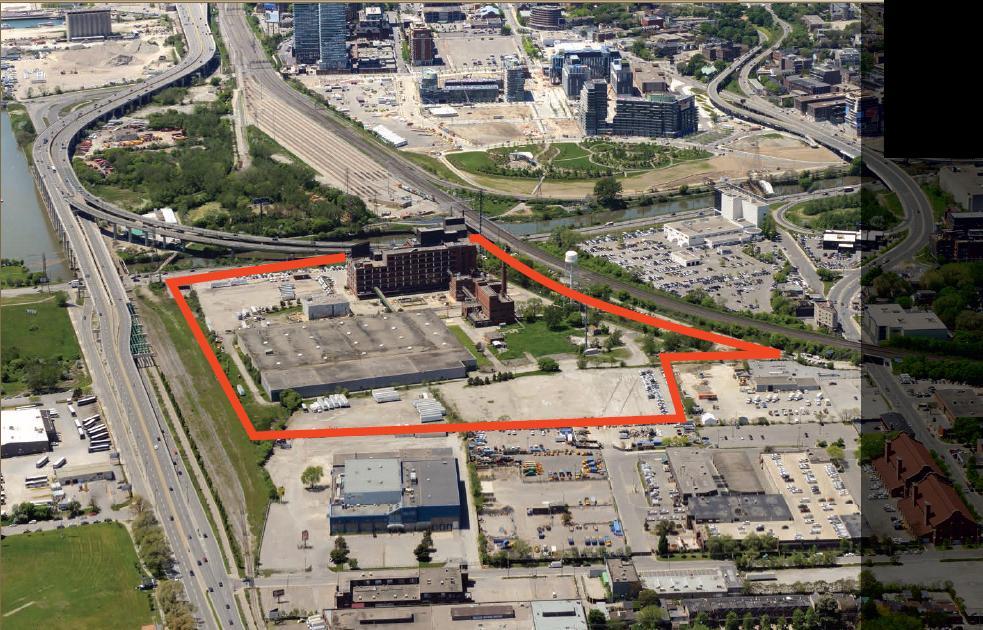 |
Image is an edit of First Gulf .pdf link titled, "Marketing Package" - at: http://www.firstgulf.com/search-details.php?id=130
|
In May 2014, during the "Gardiner East Environmental Assessment and Integrated Urban Design Study" process, First Gulf proposed a re-alignment of the Gardiner ...
Existing:
 |
Courtesy: First Gulf/BeachMirror - First Gulf - 21 Don Roadway, May 2014 Proposal, Existing Gardiner sketch
|
Proposed:
 |
Courtesy:First Gulf/BeachMirror - 21 Don Roadway - May 2014 Proposed Gardiner realignment, Broadview extension
|
... interestingly, a much larger development-area boundary is indicated in these 2014 sketches.
It includes: the entirety of the City of Toronto Transportation Services Yards at Booth Ave (large yellow rectangle in the foreground); land along the south side of Eastern from McGee west over to the rail overpass; lands to the south of the Transportation Services yards; and (I believe), the Port Authority's disused switching yard to the north of the Lower Don Recreation Trail.
Plus, about 2 years ago, while I was discussing the possibility of extending the Eastern Avenue Bike Lanes across the Don Valley to the Richmond/Adelaide Bicycle Corridor, someone from the city intimated to me that the owner of the property south of Sunlight Park Road (now BMW Canada) was key to that idea - and would need to be a part of this 21 Don Roadway development group in order for that idea to happen.
Here's hoping.
Ward 30 Bikes hasn't seen the latest First Gulf plans yet.
Below is a sketch from First Gulf that shows some transportation context - it appeared in Urban Toronto (no date of publish indicated).
Note:
- a proposed pedestrian bridge across the Don River under the Rail Line bridge;
- a new north-south street at the existing entrance to the Works and Emergency Services Yards at 433 Eatern Avenue (northern entrance to 30 Booth);
- a new east-west roadway: from Booth (at the existing 30 Booth entrance-way) to a new Broadview extention;
- a new east-west roadway from a McGee extention west to Don Roadway (at the existing entrance to 21 Don Roadway);
- a new roadway, a dog-leg from new south Broadview west, and then south to the new 21 Don Roadway parrallel roadway.
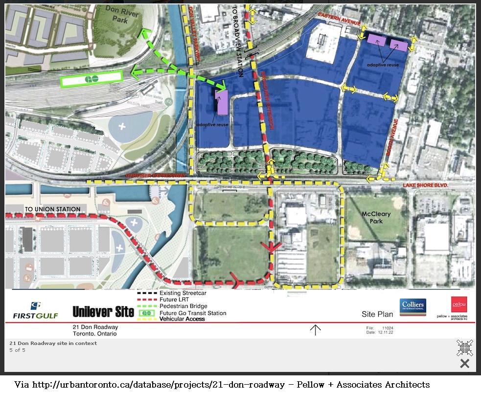 |
First Gulf/Pellow + Associates Architects/UrbanToronto - http://urbantoronto.ca/database/projects/21-don-roadway
|
Here, thus, is a map that I made for this article, of the possible extent of this master-planned neighbourhood, city building proposed development.
Google ‘My Maps’ Link: https://www.google.com/maps/d/edit?mid=zZMlzwviuib8.krmLPqc1u0mM
(I think) the map reveals how the existing roadways might be configured as part of this development so that they connect the city to the River; the city to the Waterfront; and the east side of the city to the neighbourhoods across the Don River.
In short, we are about to build a small town south of Eastern Avenue at Broadview. ... And, as a walker and a cyclist - on that scale - that means several neighbourhoods.
This raises questions, such as:
- How would Sunlight Park Road work as a connection point integrated into an extended Broadview at the chicane at Eastern Avenue - to create a safe route to a Cycling/Pedestrian Bridge over the Don Valley to Corktown Common Park - and beyond to the Richmond/Adelaide Cycling Corridor?
- With Broadview extended south to Commissioners, what is the character of a new Don Roadway?
- How do we configure the Lower Don Recreation Trail at Don Roadway?
- Do we want to naturalize the Don River Valley north of the Keating Channel - perhaps all the way up to north of Gerrard - the distance where it is currently confined by a canal wall?
- Can we plan to make the river accessible to the community via riverside park lands; places where people can walk right up to the water’s edge - and dip one’s toe in?
- Should we remove the East Gardiner, and the ramp connections to the DVP?
- Should we remove the Don Valley Parkway in favour of a “park way” for sustainable transportation?
- At the Eastern Avenue Bridge: Should we remove the ramps from Adelaide/to Richmond? What about the on-and-off ramps to the DVP?
What do you think we should be talking about to First Gulf and City Planners around this city building proposal?
What's your vision of a Lower Don River community - perhaps just 10 short years from now?
Michael Holloway
member, Ward 30 Bikesmh
No comments:
Post a Comment